Mild, dull and wet overall
October 2025 was a mild, dull, and wet month which saw the first named storm of the 2025/26 storm season. Storm Amy brought wet and very windy weather on Friday 3rd and Saturday 4th October. On Friday 3rd, Malin Head, Co. Donegal recorded its highest October 10-minute mean wind speed on record (record length 65 years) of 111km/h (violent storm force winds). Following Storm Amy, high pressure brought two weeks of mild, cloudy and relatively dry weather. Despite this, the overall rainfall was higher than average for October, with most stations recording higher rainfall totals than their Long-Term Average (LTA).
October 2025 was warmer than average with a national mean air temperature of 11.61°C. October’s highest temperature of 19.7 °C was recorded at three stations, Shannon Airport, Co Clare on Wednesday 1st, Phoenix Park, Co Dublin on Friday 3rd, and Dublin Airport, Co Dublin on Monday 6th. The lowest air minimum for the month was recorded on Wednesday 29th at Athenry, Co Galway with 1.0 °C. All stations recorded mean air temperatures above their LTA for the month. It was a dull month, with all stations recording below average sunshine for the month.
Key Figures:
- The national mean air temperature of 11.61°C (using the Island of Ireland dataset*) placed October 2025 24th warmest in 126 years, but the coolest since 2020.
- 11.61 °C is 1.02 °C above 1961-1990 LTA and 0.82 °C above the most recent 1991-2020 LTA.
- Of the top ten warmest Octobers, four have occurred since 2001 (highest first 2001, 2006, 2022 and 2013). None of the top ten coolest Octobers have occurred since 2001.
- The national gridded average rainfall of 159.2 mm ranked 23rd highest in 85 years and 123% of its 1991-2020 LTA.
- The highest gust recorded during Storm Amy was reported at Malin Head, Co. Donegal with 148 km/h, and the month’s highest 10-minute mean wind speed was 111 km/h also at Malin Head during storm Amy.
- All stations recorded below average sunshine for the month, with the number of dull days ranging from 11 days at Casement Aerodrome, Co Dublin to 17 days at Malin Head, Co Donegal.

October Climate Statement highlights
The first four days of October 2025 saw Atlantic low pressure steering a warm moisture laden tropical maritime airmass over the country from the southwest. Two Atlantic hurricanes, Humberto and Imelda, positioned between the southeast of the United States and Bermuda fuelled an intensification of the North Atlantic jet stream. While active weather fronts brought intense rainfall in the South and West of the country on Thursday 2nd, energy from the two tropical systems spawned a new area of low pressure in the Atlantic that became storm Amy, named by the Met Office (UK). Storm Amy brought widespread wet and very windy weather on Friday 3rd and Saturday 4th as it passed close to the northwest coast of Ireland moving towards northern Scotland.
As Amy pulled away on Sunday 5th, high pressure built over the country from the south. The following two weeks were dominated by high pressure and anticyclonic gloom. It stayed mild and mostly dry, apart from patches of light rain or drizzle at times, but disappointingly cloudy. There were a few sunny breaks, mostly in the Southwest.
Low pressure encroached from the west on Saturday 18th as high pressure pulled away to the east. Atlantic low pressure dominated for the remainder of October with numerous active weather fronts crossing the country bringing heavy falls of rain or showers at times interspersed with short dry periods.
Rainfall: Above average in most places
October 2025 rainfall totals were above their 1991-2020 Long-Term Average (LTA) at the majority of stations. Percentage of monthly rainfall values ranged from 84% (the month’s lowest rainfall total of 68.9 mm) at Casement Aerodrome, Co Dublin to 168% (171.4 mm) at Mount Dillon, Co Roscommon. Monthly rainfall totals were as much as 198.1 mm (115% of its LTA) at Valentia Observatory, Co Kerry. The highest daily rainfall total was also recorded at Valentia Observatory, Co Kerry with 48.1 mm on Thursday 2nd.
Twelve other stations also had their wettest day of the month on Thursday 2nd with three stations having their wettest October day on record. These were Mace Head, Co Galway (37.0 mm), Mount Dillon, Co Roscommon (36.2 mm) and Knock Airport, Co Mayo (41.4 mm) (record lengths between 17 and 28 years). Claremorris, Co Mayo with 46.4 mm had its wettest October day since 1989, Ballyhaise, Co Cavan with 40.2 mm had its wettest October day since 2002 and Athenry, Co Galway with 41.1 mm had its wettest October day since 2006.
The number of rain days* ranged from 15 days at Roches Point, Co Cork to 25 days at Finner, Co Donegal. The number of wet days* ranged from 9 days at Roches Point, Co Cork to 21 days at Newport, Co Mayo. The number of very wet days* ranged from 1 day at Phoenix Park, Co Dublin to 7 days at six stations.
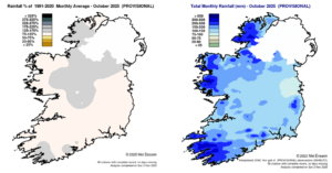
Rainfall % of 1991 – 2020 Monthly Average for October 2025 (Provisional) Total Monthly Rainfall (mm) for October 2025 (Provisional)
Temperature: Above average everywhere
All mean air temperatures across the country were above their LTA for the month. Deviations from mean air temperature ranged from +0.4 °C (11.6 °C , 12.1 °C mean temperature) at Belmullet, Co Mayo and Roches Point, Co Cork respectively to 1.5 °C (11.0 °C mean temperature) at Mount Dillon, Co Roscommon. Mean temperatures ranged from 10.1 °C (0.9 °C above its LTA) at Knock Airport, Co Mayo to 12.6 °C (0.6 °C above its LTA) at Sherkin Island, Co Cork.
The month’s highest temperature of 19.7 °C was reported at three stations, Shannon Airport, Co Clare on Wednesday 1st, Phoenix park, Co Dublin on Friday 3rd and Dublin Airport, Co Dublin on Monday 6th. The month’s lowest air minimum was recorded on Wednesday 29th at Athenry, Co Galway with 1.0 °C while the lowest grass minimum was -3.2 °C reported at Phoenix Park, Co Dublin on Sunday 26th. There was no air frost reported this month. More than half of stations reported ground frost. The number of days with ground frost ranged from zero days at a few stations to 7 days at Phoenix Park, Co Dublin.
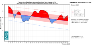
Sherkin Island, Co Cork Temperature: Daily mean departure from LTA for October 2025 based on 09-09hr Max/Min values.
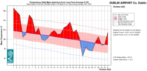
Dublin Airport, Co Dublin Temperature: Daily mean departure from LTA for October 2025 based on 09-09hr Max/Min values.
Sunshine: Below average, record dull in places
All available monthly sunshine totals were below their LTA. Percentage of monthly sunshine values ranged from 66% (67.7 hours) at Casement Aerodrome, Co Dublin (its dullest October on record) to 72% (67.5 hours) at Shannon Airport, Co Clare. Monthly sunshine totals ranged from 36.2 hours at Malin Head, Co Donegal (its dullest October on record and the dullest October on record at any station) to 75.4 hours (no LTA comparison*) at Johnstown Castle, Co Wexford.
The highest number of daily sunshine hours recorded this month was 8.3 hours at both Casement Aerodrome, Co Dublin on Wednesday 22nd and Cork Airport, Co Cork on Saturday 4th. The number of dull days2 ranged from 11 days at Casement Aerodrome, Co Dublin to 17 days at Malin Head, Co Donegal.
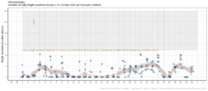
Hours of Bright Sunshine observed at nine stations for each day of the month of October 2025, grouped by province relative to the highest number of hours possible by end of month (shaded box).
Wind: Violent storm force winds reported during storm Amy
Monthly mean wind speeds ranged from 5.9 knots (10.9 km/h) at Ballyhaise, Co Cavan to 17.5 knots (32.4 km/h) at Mace Head, Co Galway. Gales were reported on 11 days during the month with strong gales reported on Friday 3rd, Saturday 4th and Thursday 30th. Mean wind speeds reached storm force at three stations (Belmullet, Co Mayo, Malin Head, Co Donegal and Mace Head, Co Galway) on Friday 3rd during storm Amy and at one station (Mace Head, Co Galway) on Saturday 4th during storm Amy. Mean wind speeds reached violent storm force 11 at Malin Head, Co Donegal on Friday 3rd during storm Amy. The number of days with gales ranged from zero days at a few stations to 8 days at Malin Head, Co Donegal. The number of days with up to strong gales ranged from zero at Dublin Airport to 2 days at a few stations. The number of days with storms force winds were up to 2 days at Mace Head, Co Galway.
Both the month’s highest gust and 10-minute mean wind speed was reported at Malin Head, Co Donegal on Friday 3rd during storm Amy. The highest gust was 80 knots (148 km/h) while the month’s highest 10-minute mean wind speed was 60 knots (111 km/h) (its highest October 10-minute mean wind speed on record (length 65 years)). Along with Malin Head, four other stations also recorded their highest 10-minute mean wind speed for October on record on Friday 3rd during storm Amy. These were Finner, Co Donegal (85 km/h), Knock Airport, Co Mayo (74 km/h), Athenry, Co Galway ( 61 km/h) and Ballyhaise, Co Cavan (59 km/h). Finner (115 km/h), Ballyhaise (100 km/h) and Athenry (100 km/h) also reported their highest October gust on record on Friday 3rd during storm Amy.
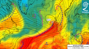
Airmass Analysis chart 12 UTC 3 October 2025: Storm Amy brought violent storm force winds to Donegal.
Full PDF report and charts are available here
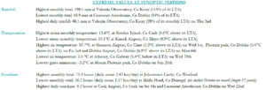
Extreme values for October 2025 at synoptic stations.
Notes to Editor:
- *Issued by Met Éireann on Tuesday 4th November 2025. This report is based on available preliminary data from 25 principal weather stations operated by Met Éireann. Synoptic station data is midnight to midnight UTC. Long-Term Averages (LTAs) and “average” refer to the period 1991-2020 unless stated.
- A rain day is a day on which 0.2 mm or more of rainfall is measured. A wet day is a day with 1.0 mm or more of rainfall. A dull day is a day with less than 0.5 hours of sunshine. A very wet day is a day with 10.0 mm or more of rainfall.
- Climatological dry periods – An absolute drought is a period of 15 or more consecutive days to none of which is credited 0.2 mm or more of precipitation. A partial drought is a period of at least 29 consecutive days, the mean daily rainfall of which does not exceed 0.2 mm. A dry spell is a period of 15 or more consecutive days to none of which is credited 1.0 mm or more of precipitation (i.e. daily tot < 1.0 mm).
- A heatwave occurs where there are 5 consecutive days or more with maximum temperature over 25°C (that is, a daily maximum screen air temperature > 25° C).
- The ‘Island of Ireland’ dataset is 125 years long and runs between 1900 and 2023. For this dataset the long term averages from the 1961-1990 reference period are used for comparison as is standard for long-term climate change assessments.
- Sunshine data is from the Autosol Network. LTAs for these sites are currently not used for comparison purposes.
- For more information or interview opportunities with a Met Éireann spokesperson, please contact us at enq@met.ie.