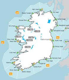
Sea Area Forecast
Forecast valid from: 18:00, Friday 13 February 2026 until 18:00, Saturday 14 February 2026
Small Craft Warning
1: North to northeast will reach force 6 or higher on Irish coasts from Wicklow Head to Roches Point to Loop Head this evening.
2: Southerly winds will reach force 6 or higher on Irish coasts from Mizen Head to Slyne Head to Malin Head from Saturday morning, extending to all coast by Saturday afternoon.
Gale Warning
Southerly winds will reach gale force 8 at times from Roche's Point to Loop Head to Bloody Foreland from Saturday morning.
Atlantic Swell
On Atlantic Coasts
Meteorological Situation at 15:00 UTC
Low pressure of 988hPa southeast of Ireland extends a broad trough northwest of the country. Several wrap around fronts are embedded in the flow. A ridge of high pressure lies in the Mid Atlantic.
Gale Warning: In effect
Small Craft Warning: In effect
Heavy Swell (>4m) : yes
Forecast for Carlingford Lough to Roches Point to Loop Head and for the Irish Sea
Wind: Northerly force 6 or 7. Soon easing northerly force 5 or 6. Later becoming southerly force 7 or 8
Weather: Cloudy with rain developing later, heavy at times.
Visibility: Reducing moderate or poor in rain.
Forecast for Loop Head to Malin Head to Carlingford Lough
Wind: Northerly force 3 or 4. Soon easing variable force 3 or less. Later becoming southerly force 6 or 7, occasionally gale force 8.
Weather: Cloudy with rain developing later, heavy at times.
Visibility: Reducing moderate or poor in rain.
Outlook for a further 24 hours until 18:00, Sunday 15 February 2026
Fresh to strong southerly winds, increasing to near gale force in the west and northwest Saturday afternoon. Becoming fresh to strong westerly overnight Saturday and into Sunday morning. Increasing strong to near gale westerly in the west Sunday morning. Weather: Rain, heavy at time and falling as sleet or snow in the northwest followed by showers from Sunday morning.
Forecast issued at: 18:00, Friday 13 February 2026
All times are local unless specified
