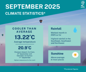
Cool and wet September, sunnier than average
September 2025 was the wettest month of 2025 so far and was relatively cool overall. All stations recorded rainfall above their 1991-2020 Long-Term Average (LTA) for the month making this month the 18th wettest September since 1940. The highest daily rainfall total was 31.0 mm at Johnstown Castle, Co Wexford on Friday 19th.
Although September 2025 saw some warm temperatures, the highest recorded temperature of 20.9°C on Tuesday 9th at Shannon Airport, Co Clare and again on Wednesday 17th at Oak Park, Co Carlow, the month was overall cooler than average with all stations recording temperatures below their LTA. Throughout September 2025, Atlantic low pressure dominated. Ireland was often situated on the colder northern side of the jet stream in Polar maritime or returning Polar maritime air masses. Most stations recorded above average sunshine, with the highest number of daily sunshine hours recorded this month was 11.1 hours at Johnstown Castle, Co Wexford on Monday 22nd.
Key Figures:
- Provisional gridded data indicates that September 2025 was the wettest month of 2025 so far, observed average 141.0 mm which is 142% of the 1991-2020 LTA, the 18th wettest September since 1940.
- September 2025 had an average temperature of 13.22 °C (using the Island of Ireland dataset*), similar to September 2024 which had an average temperature 13.21 °C.
- Ranked 62nd warmest September or 65th coolest, September 2025 was 0.27 °C above 1961-1991 long-term average for the month, or 0.38 °C below the long-term average for the most recent climatological reference period of 1991-2020.
- Of the top ten warmest Septembers, six have occurred since 2001 (highest first 2021, 2006, 2023, 2016, 2005 and 2014).
- Of the top ten coolest Septembers, zero have occurred since 2001, the most recent was in 1992 (9th coolest, 11.79 °C).
September Climate Statement highlights
The first third of the month saw a mobile Atlantic setup with low pressure, mostly situated to the north and west, steering several weather fronts across the country. This brought scattered outbreaks of rain or showers on most days, sometimes heavy and thundery, interspersed with drier periods.
The second third of the month continued in a similar vein with Atlantic low pressure systems to the north and west dominating. Several active weather fronts crossed the country bringing spells of rain, heaviest in the West, interspersed with heavy and sometimes thundery showers.
The final third of the month was drier. High pressure moved in from the west, preceded by a cool northerly wind. The high pressure system slowly moved from west to east and brought several mostly dry days with plenty of sunshine.
On Monday 27th the drier spell ended as a frontal trough gradually pushed in from the west bringing a band of rain across the country. Pressure remained high for the following few days before Atlantic low pressure took control once again at the end of the month bringing further rain or showers.
Rainfall: Above average everywhere, wettest in the Southwest, Northwest and Southeast
September 2025 rainfall totals were above their monthly 1991-2020 Long-Term Average (LTA). Percentage of monthly rainfall values ranged from 106% (77.7 mm) at Dunsany, Co Meath to 191% (161.3 mm) at Johnstown Castle, Co Wexford. Monthly rainfall totals ranged from 73.7 mm (120% of its LTA) at Casement Aerodrome, Co Dublin to 218.0 mm (168% of its LTA) at Valentia Observatory, Co Kerry (its wettest September since 2006). The highest daily rainfall total was 31.0 mm at Johnstown Castle, Co Wexford on Friday 19th.
The number of rain days* ranged from 19 days at Roches Point, Co Cork to 25 days at both Newport, Co Mayo and Knock Airport, Co Mayo. The number of wet days* ranged from 14 days at Dublin Airport, Co Dublin to 23 days at both Newport, Co Mayo and Valentia Observatory, Co Kerry. The number of very wet days* ranged from 1 day at a few stations to 10 days at Newport, Co Mayo. There were up to six consecutive dry days, that is when no more than 0.0 mm of rain fell any day, at Roches Point (coastal), Co Cork and Mount Dillon, Co Roscommon between Sunday 21st and Friday 26th inclusive.
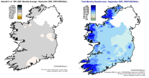
Rainfall % of 1991 – 2020 Monthly Average for September 2025 (Provisional) Total Monthly Rainfall (mm) for September 2025 (Provisional)
Temperature: Below average everywhere
All mean air temperatures across the country were below their LTA for the month. Deviations from mean air temperature ranged from -0.8 °C (12.5 °C) at Cork Airport, Co Cork to -0.1 °C at Malin Head, Co Donegal (13.2 °C) and Mace Head, Co Galway (13.8 °C). Mean temperatures ranged from 11.7 °C (0.4 °C below its LTA) at Knock Airport, Co Mayo to 13.9 °C (0.3 °C below its LTA) at Sherkin Island, Co Cork. The month’s highest temperature was reported at both Oak Park, Co Carlow on Wednesday 17th and Shannon Airport, Co Clare on Tuesday 9th with a temperature of 20.9 °C. Both the month’s lowest air and grass minimum temperatures were recorded on Monday 22nd at Mount Dillon, Co Roscommon. The lowest air minimum was -0.6 °C while the lowest grass minimum was -4.4 °C.
More than half of stations reported ground frost. The number of days with ground frost ranged from zero days at a few stations to 7 days at Oak Park, Co Carlow. One station, Mount Dillon, Co Roscommon, reported air frost on one day during the month (Monday 22nd). It was the coolest September since 2018 at thirteen stations.
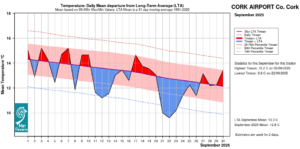
Cork Airport, Co Cork Temperature: Daily mean departure from LTA for September 2025 based on 09-09hr Max/Min values.
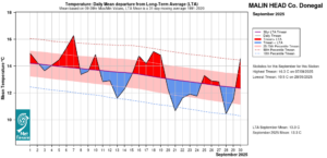
Malin Head, Co Donegal Temperature: Daily mean departure from LTA for September 2025 based on 09-09hr Max/Min values.
Sunshine: Generally above average, sunniest in the South
All available sunshine totals were above their LTA. Percentage of monthly sunshine values ranged from 109% (137.4 hours) at Casement Aerodrome, Co Dublin to 127% (150.6 hours) at Shannon Airport, Co Clare. Monthly sunshine totals ranged from 112.4 hours (no LTA comparison*) at Valentia Observatory, Co Kerry to 160.8 hours (no LTA comparison*) at Cork Airport, Co Cork. The highest number of daily sunshine hours recorded this month was 11.1 hours at Johnstown Castle, Co Wexford on Monday 22nd. The number of dull days* ranged from 2 days at both Shannon Airport, Co Clare and Dublin Airport, Co Dublin to 7 days at Valentia Observatory, Co Kerry.
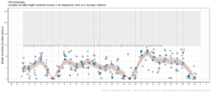
Hours of Bright Sunshine observed at nine stations for each day of the month of September 2025, grouped by province relative to the highest number of hours possible by end of month (shaded box).
Wind: Strong gales reported
Monthly mean wind speeds ranged from 5.7 knots (10.6 km/h) at Moore Park, Co Cork and Mount Dillon, Co Roscommon to 17.2 knots (31.9 km/h) at Mace Head, Co Galway. Gales were reported at six stations through the month. Gales were reported on Wednesday 10th, Friday 12th, Sunday 14th, Monday 15th and Saturday 20th. Strong gale force winds were reported on Sunday 14th and Monday 15th at Mace Head, Co Galway. The number of days with gales ranged from zero days at a most stations to 4 days at Mace Head, Co Galway. The number of days with up to strong gales ranged from zero days at most stations to 2 days at Mace Head, Co Galway. Both the month’s highest gust and 10-minute mean wind speed was reported at Mace Head, Co Galway on Monday 15th. The highest gust was 59 knots (109 km/h) while the month’s highest 10-minute mean wind speed was 46 knots (85 km/h).
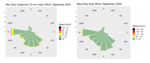
Wind roses for September 2025, sustained 10-min mean and gust.
Full PDF report and charts are available here
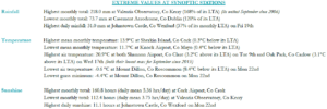
Extreme values for September 2025 at synoptic stations.
Notes to Editor:
- *Issued by Met Éireann on Thursday 2nd October 2025. This report is based on available preliminary data from 25 principal weather stations operated by Met Éireann. Synoptic station data is midnight to midnight UTC. Long-Term Averages (LTAs) and “average” refer to the period 1991-2020 unless stated.
- A rain day is a day on which 0.2 mm or more of rainfall is measured. A wet day is a day with 1.0 mm or more of rainfall. A dull day is a day with less than 0.5 hours of sunshine. A very wet day is a day with 10.0 mm or more of rainfall.
- Climatological dry periods – An absolute drought is a period of 15 or more consecutive days to none of which is credited 0.2 mm or more of precipitation. A partial drought is a period of at least 29 consecutive days, the mean daily rainfall of which does not exceed 0.2 mm. A dry spell is a period of 15 or more consecutive days to none of which is credited 1.0 mm or more of precipitation (i.e. daily tot < 1.0 mm).
- A heatwave occurs where there are 5 consecutive days or more with maximum temperature over 25°C (that is, a daily maximum screen air temperature > 25° C).
- The ‘Island of Ireland’ dataset is 125 years long and runs between 1900 and 2023. For this dataset the long term averages from the 1961-1990 reference period are used for comparison as is standard for long-term climate change assessments.
- Sunshine data is from the Autosol Network. LTAs for these sites are currently not used for comparison purposes.
- For more information or interview opportunities with a Met Éireann spokesperson, please contact us at enq@met.ie.