Wet and relatively mild overall, drier in the Northwest
March 2024 saw Atlantic low pressure systems continue to dominate with a southerly displaced jet stream bringing the bulk of the rain to the Midlands, South and East. Daytime temperatures were cool at times, but mostly mild nighttime temperatures kept the overall means above average.
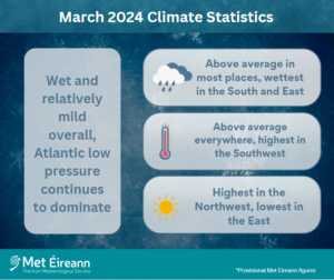
March 2024 Climate Statistics
On the first day of the month a trough of low pressure crossed the country with cold air wrapped around it. A weather front associated with this low stalled over the east of the country and brought a prolonged spell of heavy rain, which turned wintry at times with snow settling on the ground in places. Low pressure to the west stayed in control for the rest of the first week with rain or showers on most days. High pressure over Scandinavia brought a period of easterly winds with a few relatively dry days at the beginning of the second week. Low pressure to the south pushed weather fronts north over the country during the second half of the week, bringing spells of rain, heaviest in the South. The third week saw Atlantic low pressure, this time to the northwest, steering a few relatively weak weather fronts across the country from the west, interspersed with sunshine and showers. The fourth week began showery in a north-westerly airflow before Atlantic low pressure settled over the country on the 24th and brought several frontal rain bands, sometimes heavy, across the country in a cyclonic airflow up to the end of the week. The final few days of the month were showery with longer sunny spells in between.
Rainfall: Above average in most places, wettest in the South and East
- Dublin Airport, Co Dublin had its third wettest March on record, behind 2023 and 1947 (length 82 years))
- Dublin Airport and Phoenix Park, Co Dublin had their wettest March day on record on Friday 1st
- Mount Dillon, Co Roscommon had its wettest March day on record on Thursday 14th
- Valentia Observatory, Co Kerry had its wettest March since 1963
- All stations had 20 or more rain days* with 29 rain days at both Shannon Airport, Co Clare and Ballyhaise, Co Cavan.
The majority of monthly rainfall totals were above their 1981-2010 Long-Term Average (LTA). Percentage of monthly rainfall values ranged from 79% (the month’s lowest monthly rainfall total of 82.4 mm) at Finner, Co Donegal to 219% (monthly rainfall total of 115.4 mm) at Dublin Airport, Co Dublin (its third highest March rainfall on record, behind 2023 and 1947 (length 82 years)). Monthly rainfall totals were as much as 239.8 mm (194% of its LTA) at Valentia Observatory, Co Kerry (its wettest March since 1963). The highest daily rainfall total was 45.3 mm at Dublin Airport on Friday 1st (its highest daily fall for March on record (length 82 years)). The number of rain days* ranged from 20 days at Belmullet, Co Mayo to 29 days at both Shannon Airport, Co Clare and Ballyhaise, Co Cavan. The number of wet days* ranged from 14 days at Malin Head, Co Donegal to 26 days at Valentia Observatory, Co Kerry. The number of very wet days* ranged from 1 day at Dublin Airport to 8 days at both Valentia Observatory, Co Kerry and Cork Airport, Co Cork. Along with Dublin Airport, Phoenix Park, Co Dublin also had its wettest March day on record on Friday 1st with 43.9 mm (length 83 years), while Mount Dillon, Co Roscommon had its wettest March day on record on Thursday 14th with 33.6 mm (length 19 years).
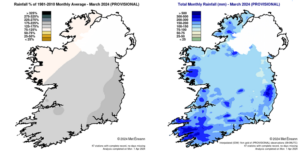
Rainfall % of 1981 – 2010 Monthly Average for March 2024 (Provisional) Total Monthly Rainfall (mm) for March 2024 (Provisional)
Temperature: Above average everywhere, highest in the Southwest
- All stations had above average mean temperatures for March
- Less than half of stations reported air frost
- Five stations had their highest minimum temperature for March on record
All mean air temperatures across the country were above their LTA for the month. Deviations from mean air temperature ranged from 0.1 °C at Mace Head, Co Galway (8.0 °C mean temperature) and Markree, Co Sligo (7.1 °C mean temperature) to 1.1 °C at Phoenix Park, Co Dublin (7.7 °C mean temperature), Dunsany, Co Meath (7.3 °C mean temperature) and Moore Park, Co Cork (8.0 °C mean temperature). Mean temperatures for the month ranged from 6.4 °C (0.7 °C above its LTA) at Knock Airport, Co Mayo to 9.1 °C (0.7 °C above its LTA) at Sherkin Island, Co Cork. All the month’s highest and lowest temperatures were recorded at Mount Dillon, Co Roscommon with both the lowest air and grass minimum temperatures reported on Friday 29th. The minimum air temperature was -2.7 °C while the lowest grass minimum was -7.1 °C. The high maximum was reported on Sunday 31st with a temperature of 16.3 °C. More than half of stations reported ground frost. The number of days with ground frost ranged from zero days at a few stations to 18 days at Mullingar, Co Westmeath. Less than half of stations reported air frost. The number of days with air frost ranged from zero days at a few stations to 7 days at Markree, Co Sligo. Five stations, with no air frost during March, had their highest minimum temperature for March on record (record lengths range from 19 to 84 years). These were Phoenix Park, Co Dublin, Moore Park, Co Cork, Roches Point, Co Cork, Dunsany, Co Meath and Valentia Observatory, Co Kerry.
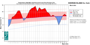
Sherkin Island, Co Cork Temperature: Daily mean departure from LTA for March 2024 based on 09-09hr Max/Min values.
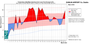
Dublin Airport, Co Dublin Temperature: Daily mean departure from LTA for March 2024 based on 09-09hr Max/Min values.
Sunshine: Highest in the Northwest, lowest in the East
Percentage of monthly sunshine values ranged from 92% (monthly sunshine total of 93.5 hours) at Casement Aerodrome, Co Dublin to 107% (monthly sunshine total of 107.0 hours) at Shannon Airport, Co Clare. Monthly sunshine totals ranged from 84.0 hours (No LTA comparison*) at Dublin Airport to 111.9 hours (No LTA comparison*) at Malin Head, Co Donegal. The highest number of daily sunshine hours recorded this month was 10.6 hours at Johnstown Castle, Co Wexford on Saturday 23rd (its highest daily sunshine for March since 2000). The number of dull days* ranged from 8 days at a few stations to 11 days at both Valentia Observatory, Co Kerry and Cork Airport, Co Cork.
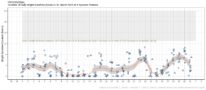
Hours of Bright Sunshine observed at each station for each day of the month, grouped by province relative to the highest number of hours possible by end of month (shaded box)
Wind: Strong gales reported
Monthly mean wind speeds ranged from 6.9 knots (12.8 km/h) at Ballyhaise, Co Cavan to 17.0 knots (31.5 km/h) at Malin Head, Co Donegal. Gales were reported on 10 days during the month with up to strong gale winds reported on Tuesday 5th and Wednesday 27th. The number of days with gales ranged from zero days at a few stations to 8 days at Malin Head, Co Donegal. The number of days with up to strong gales ranged from zero at most stations to 1 day at both Mace Head, Co Galway and Malin Head, Co Donegal. The month’s highest gust was reported at Newport, Co Mayo on Saturday 23rd with 57 knots (105 km/h). The month’s highest 10-minute mean wind speed was 44 knots (82 km/h) at Mace Head, Co Galway on Tuesday 5th.
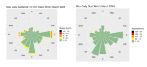
Wind roses for March 2024
The full report is available at https://www.met.ie/climate/past-weather-statements
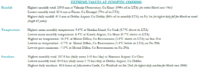
Extreme values for March 2024 at synoptic stations
*Issued by Met Éireann on Thursday 4th January 2024. This report is based on available preliminary data from 25 principal weather stations operated by Met Éireann. Synoptic station data is midnight to midnight UTC. Long-Term Averages (LTAs) and “average” refer to the period 1981-2010 unless stated. A rain day is a day on which 0.2 mm or more of rainfall is measured. A wet day is a day with 1.0 mm or more of rainfall. A dull day is a day with less than 0.5 hours of sunshine. A very wet day is a day with 10.0 mm or more of rainfall. Climatological dry periods – An absolute drought is a period of 15 or more consecutive days to none of which is credited 0.2 mm or more of precipitation. A partial drought is a period of at least 29 consecutive days, the mean daily rainfall of which does not exceed 0.2 mm. A dry spell is a period of 15 or more consecutive days to none of which is credited 1.0 mm or more of precipitation (i.e. daily tot < 1.0 mm). A heatwave occurs where there are 5 consecutive days or more with maximum temperature over 25°C (that is, a daily maximum screen air temperature > 25° C). The Island of Ireland dataset is 125 years long and runs between 1900 and 2023. For this dataset the long term averages from the 1961-1990 reference period are used for comparison as is standard for long-term climate change assessments. *Sunshine data is from the Autosol Network. LTAs for these sites are currently not used for comparison purposes. For more information, contact Met Éireann at 01-8064200 or e-mail: enq@met.ie