Changeable, dull and windy:
After a couple of warm, sunny days at the beginning of June, a change in the overall pattern led to low pressure dominating the rest of the month. As high pressure pulled away to the west at the beginning of the first week, a northerly airflow brought weak weather fronts and showers southwards across the country. An upper level trough of low pressure moved south during the second week and became cut off over the Bay of Biscay. This drew up an unstable warm and humid air mass from the southeast, which culminated in intense thunderstorm activity between the 13th and 16th. The thunderstorms were widespread over the four days but some places escaped, especially along the east coast. A slack airflow followed for a few days before a deep area of low pressure in the Atlantic sent several active weather fronts across the country in a south-westerly airflow between the 20th and 23th, with widespread rain.
A weather front stalled across the Midlands and West on the 23rd, before fizzling out and pushing back west on the 24th. A warm and humid air mass moved in over the country once again from the southeast on the 25th as a trough of low pressure approached from the west. This led to another round of intense thunderstorms late on the 25th and through the 26th, mostly affecting the Southeast and Northwest. The remainder of the month saw low pressure developing to the north of Ireland, which brought unseasonably strong winds along with some heavy and prolonged rainfall, especially in the Northwest.
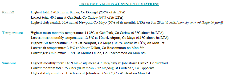
Rainfall was above average for most, highest in the Northwest. Temperatures were near average at most places. Sunshine amounts were below average everywhere. Monthly mean wind speeds ranged from 5.8 knots (10.7 km/h) at Ballyhaise, Co Cavan to 13.1 knots (24.3 km/h) at Mace Head, Co Galway. Gales were reported on the 5th, 6th, 20th and 28th.
 Full report <<here>>