Exceptionally warm, dry and sunny
July 2026 was the 2nd hottest July since 1900 and the driest July on record, and one of the sunniest months on record for Ireland. This was due to high pressure dominance, which saw numerous station records being broken. Heatwaves were recorded at 7 stations, lasting between 5 and 13 days. Moore Park experienced the second longest heatwave on record with 13 days. The South and the East experienced long dry periods of high temperatures and sunshine, while the North and West experienced some rain and cloud, particularly early and late in the month. In the last week of the month, the high pressure moved away to the southwest, bringing cloud, with some rain and showers.
Key National Figures:
- The national mean July temperature was 17.25 °C, making it the 2nd hottest July since 1900 (behind July 2013, 17.34 °C). It was also the 3rd hottest month overall (the hottest month remains August 1995, 17.75 °C)
- 17.25 °C is 2.40 °C above the 1961-1990 LTA and 1.87 °C above the 1991-2020 LTA.
- Five of the ten warmest Julys have occurred since 2001, while none of the ten coolest Julys occurred recently.
- The coolest July on record was in 1922 with a mean temperature of 12.68 °C.
- Provisional gridded rainfall for Ireland shows July 2026 was the driest July on record with 16 mm or 17 % of the 1991-2020 LTA.
- Of the top ten wettest Julys, half have occurred since 2001 (highest first 2023, 2009, 2010, 2020 and 2007). Of the top ten driest Julys, two have now occurred since 2001 (lowest first 2026 and 2022).
Key Station Figures:
- Cork Airport had its driest, warmest, and sunniest month on record in July 2026.
- Johnstown Castle, Co Wexford had its driest and sunniest month on record and provisionally broke the national record for the sunniest month on record with 332.4 hours of sunshine.
- Moore Park, Co Cork and Oak Park, Co Carlow had their driest and warmest month on record.
- Phoenix Park and Casement Aerodrome, Co Dublin had their warmest month on record and driest July on record, while Valentia Observatory, Co Kerry and Roches Point, Co Cork had their warmest July on record (with record lengths for both Phoenix Park and Valentia going back 127 years).
- Heatwaves were reported at 7 stations lasting between 5 and 13 days. Moore Park, with 13 days, had the second longest heatwave on record for Ireland, behind 14 days set in Birr, Co Offaly and Ballybrittas, Co Laois in August 1976.
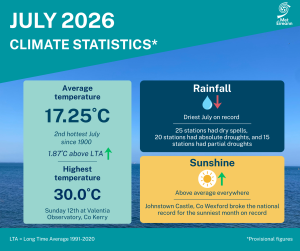
July Climate Statement highlights.
July 2026 was dominated by high pressure, which resulted in one of the hottest, driest and sunniest months on record for Ireland. Atlantic weather fronts were kept away to the north and west for most of the month. Any fronts that did encroach brought some cloud and rain, mostly to the North and West, but it stayed predominantly dry elsewhere. This setup resulted in a lot of sunshine, especially for the South and East, along with consistently high temperatures.
The first week saw high pressure to the south steering a warm and moist westerly airflow across the country with some embedded weak weather fronts. This brought light rain and drizzle at times, especially to the West and North, but as the week progressed it got drier, warmer and sunnier.
During the second week high pressure built over and then to the north of Ireland. It stayed mostly dry and very warm or hot in most places. It also became sunnier in the West as the airflow became easterly.
The third week saw the high pressure move to the west of Ireland changing the airflow to a more northerly direction. It stayed mostly dry but cooled down a bit over the northern half of the country with more cloud for the Northwest.
During the fourth week the high pressure pulled away to the southwest allowing an Atlantic westerly airflow to take hold. This brought more cloud overall and some frontal rain or showers at times, mostly to the West and North, but the South and East stayed generally dry. The month finished slightly cooler and mostly dry with high pressure to the west.
Rainfall: Exceptionally dry, driest month on record for parts of the South
- 17 stations had their driest July on record.
- 4 stations in the South had their driest month on record.
- Climatological dry periods occurred at all 25 stations during July. 25 stations had dry spells, 20 stations had absolute droughts, and 15 stations had partial droughts.
All monthly rainfall totals across the country were below their 1991-2020 Long-Term Average (LTA). Percentage of monthly rainfall values ranged from 1% at both Cork Airport, Co Cork (1.1 mm) and Moore Park, Co Cork (1.1 mm) (both their driest July and month on record (record length 64 and 62 years respectively)) to 72% (61.5 mm) at Malin Head, Co Donegal. Monthly rainfall totals ranged from 1.1 mm at both Cork Airport and Moore Park, Co Cork to 75.2 mm (67% of its LTA) at Newport, Co Mayo. The highest daily rainfall total was 17.8 mm at Belmullet, Co Mayo on Monday 27th. The number of rain days* ranged from 1 day at Johnstown Castle, Co Wexford to 17 days at Malin Head, Co Donegal. The number of wet days* ranged from zero days at a few stations to 11 days at Newport, Co Mayo. The number of very wet days* ranged from zero days at most stations to 3 days at Newport, Co Mayo.
Climatological dry periods occurred at all stations during July. All 25 stations saw dry spells* between Wednesday July 1st and Sunday August 2nd lasting between 19 and 33 days. Of those, 20 stations mostly in the Midlands, South and East also saw absolute droughts* between Wednesday 1st July and Tuesday 28th July lasting between 15 and 27 days. Of those, 15 stations in the Midlands, South and East also saw partial droughts* between Saturday 20th June and Monday 3rd August lasting between 29 and 45 days (with three stations in the East and Southeast still ongoing up to 3rd August). 17 stations had their driest July on record. Of those, 4 stations in the South, Cork Airport (1.1 mm), Moore Park (1.1 mm), Oak Park, Co Carlow (1.5 mm) and Johnstown Castle, Co Wexford (1.5 mm), had their driest month on record (record lengths between 21 and 85 years).
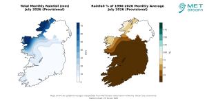
Total Monthly Rainfall (mm) for July 2026 (Provisional). Rainfall % of 1991 – 2020 Monthly Average for July 2026 (Provisional).
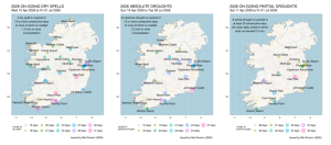
Climatological Dry Periods that were ongoing through July 2026: 25 stations saw dry spells* between Wednesday July 1st and Sunday August 2nd lasting between 19 and 33 days. Of those, 20 stations mostly in the Midlands, South and East also saw absolute droughts* between Wednesday 1st July and Tuesday 28th July lasting between 15 and 27 days. Of those, 15 stations in the Midlands, South and East also saw partial droughts* between Saturday 20th June and Monday 3rd August lasting between 27 and 45 days
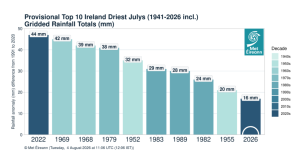
Provisional top 10 driest Julys since 1941.
Temperature: Significantly above average everywhere, record high in parts of the South and East
- 8 stations in the South and East had their warmest July on record.
- 4 stations in the South and East had their warmest month on record
- Phoenix Park, Co Dublin reported 36 consecutive days with maximum daily temperatures above 20 °C between June 30th and August 4th (still ongoing). This surpasses the previous record at a synoptic station of 34 days at Shannon Airport set in July/August 1995 and surpasses its own record of 27 days set in July 1989.
- Valentia Observatory, Co Kerry with 30.0 °C had its highest July and all-month daily maximum air temperature on record (length 127 years).
All mean air temperatures across the country were above their LTA for the month. Deviations from mean air temperature ranged from +0.7 °C (15.1 °C ,the month’s lowest mean temperature) at Malin Head, Co Donegal to +3.4 °C (18.5 °C) at Cork Airport, Co Cork (its warmest July and month on record (length 64 years)). Mean temperatures were as much as 18.8 °C (3.3 °C above its LTA) at Moore Park, Co Cork (its warmest July and month on record (length 62 years)). The month’s lowest temperatures were recorded on Friday 31st. The lowest air minimum of 5.1 °C was reported at Mullingar, Co Westmeath and the lowest grass minimum of 0.7 °C was reported at Dunsany, Co Meath. The highest maximum was reported on Sunday 12th at Valentia Observatory, Co Kerry with a temperature of 30.0 °C (its highest July and all-month daily maximum air temperature on record (length 127 years)). There was no air or ground frost reported this month.
Heatwaves* were reported at 7 stations between Sunday 5th and Friday 17th lasting between 5 and 13 days. Oak Park, Co Carlow with 12 days broke its previous longest heatwave record by one day, set in June/July 2018. Moore Park, Co Cork with 13 days broke its previous longest heatwave record by three days, set in July 2021. Moore Park, with 13 days, had the second longest heatwave on record for Ireland, behind 14 days set in Birr, Co Offaly and Ballybrittas, Co Laois in August 1976 (Note: the Average temperature in Birr, Co Offaly during its 14 day heatwave in 1976 was 17.9 °C, while the average temperature in Moore Park, Co Cork during its 13 day heatwave in 2026 was 20.4 °C, a difference of 2.5 °C).
8 stations in the South and East had their warmest July on record. Of those, 4 stations, Cork Airport (18.5 °C mean temp), Moore Park (18.8 °C), Phoenix Park, Co Dublin (18.2 °C) and Casement, Co Dublin (18.0 °C) had their warmest month on record (record lengths between 62 and 127 years). Phoenix Park, Co Dublin reported 36 consecutive days with maximum daily temperatures above 20 °C between June 30th and August 4th (still ongoing). This surpasses the previous record at a synoptic station of 34 days at Shannon Airport set in July/August 1995 and surpasses its own record of 27 days set in July 1989.
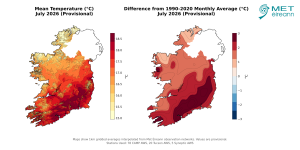
Mean Temperature (°C) for July 2026 (Provisional). Difference from 1991-2020 LTA (°C) for July 2026 (Provisional)
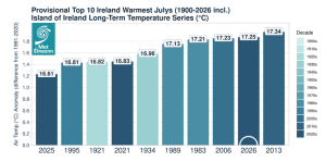
Provisional top 10 warmest Julys in Ireland since 1900.
Sunshine: Record breaking sunshine in the South and East
- 2 stations, Cork Airport and Johnstown Castle provisionally broke the National highest July and all-month sunshine duration record for Ireland.
- Casement Aerodrome, Co Dublin had its sunniest July on record and Shannon Airport, Co Clare had its sunniest July since 1955.
All available sunshine totals were above their LTA. Percentage of monthly sunshine values ranged from 172% (264.0 hours) at Casement Aerodrome, Co Dublin (its sunniest July on record (length 62 years)) to 183% (247.7 hours) at Shannon Airport, Co Clare (its sunniest July since 1955). Monthly sunshine totals ranged from 133.7 hours (no LTA comparison*) at Malin Head, Co Donegal to 332.4 hours (no LTA comparison*) at Johnstown Castle, Co Wexford (the highest July and all-month sunshine duration on record for Ireland. The previous record was 308.2 hours at Valentia, Co Kerry in July 1955). Cork Airport, Co Cork also had its sunniest month on record and surpassed the previous all-month sunshine duration record with 315.1 hours (No LTA comparison*).
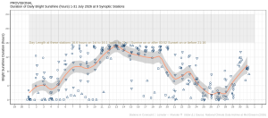
Hours of Bright Sunshine observed at nine stations for each day of the month of July 2026, grouped by province relative to the highest number of hours possible by end of month (shaded box).
Wind: Gales reported at one station
Monthly mean wind speeds ranged from 5.2 knots (9.6 km/h) at Ballyhaise, Co Cavan to 13.0 knots (24.1 km/h) at Malin Head, Co Donegal. Gales were reported on Wednesday 1st at Malin Head, Co Donegal. The number of days with gale force winds ranged from zero days at most stations to 1 day at Malin Head, Co Donegal. There were no strong gales or storms reported this month. Both the month’s highest gust and 10-minute mean wind speed was reported at Malin Head, Co Donegal on Wednesday 1st. The highest gust was 47 knots (87 km/h) while the month’s highest 10-minute mean wind speed was 36 knots (67 km/h).
Full PDF report and charts are available here
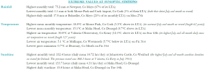
Extreme values for July 2026 at synoptic stations.
Notes to Editor:
- *Issued by Met Éireann on Wednesday 5th August 2026. This report is based on available preliminary data from 25 principal weather stations operated by Met Éireann. Synoptic station data is midnight to midnight UTC.
- Overnight highest minimum temperatures and tropical nights are measured 9am to 9am (09-09) according to WMO standards. A tropical night is the count of days when the daily minimum temperature, is greater than 20 °C (09-09).
- Long-Term Averages (LTAs) and “average” refer to the period 1991-2020 unless stated.
- A rain day is a day on which 0.2 mm or more of rainfall is measured. A wet day is a day with 1.0 mm or more of rainfall. A dull day is a day with less than 0.5 hours of sunshine. A very wet day is a day with 10.0 mm or more of rainfall.
- Climatological dry periods – An absolute drought is a period of 15 or more consecutive days to none of which is credited 0.2 mm or more of precipitation. A partial drought is a period of at least 29 consecutive days, the mean daily rainfall of which is less than or equal to 0.2 mm. A dry spell is a period of 15 or more consecutive days to none of which is credited 1.0 mm or more of precipitation (i.e. daily tot < 1.0 mm).
- A heatwave occurs where there are 5 consecutive days or more with maximum temperature over 25°C (that is, a daily maximum screen air temperature > 25° C).
- The ‘Island of Ireland’ dataset is 125 years long and runs between 1900 and 2023. For this dataset the long term averages from the 1961-1990 reference period are used for comparison as is standard for long-term climate change assessments.
- Sunshine data is from the Autosol Network. LTAs for these sites are currently not used for comparison purposes.
- For more information or interview opportunities with a Met Éireann spokesperson, please contact us at enq@met.ie.