Cold, dry and sunny with two named storms
January 2024 began with Atlantic low pressure in control bringing rain or showers. Storm Henk, named by the Met Office (UK), mostly missed Ireland to the south on Tuesday 2nd. Pressure gradually rose with an area of high pressure settling to the northeast of Ireland by the end of the first week. This brought a much cooler and drier easterly airflow for several days with more sunshine. High pressure, centred directly over or just to the north of Ireland, remained in control for the second week, which kept it mostly dry and cool but cloudy at times. High pressure began to pull away towards Greenland by the end of the second week, allowing an arctic air mass to move down from the north for most of the third week. This brought the coldest period of the month with widespread severe frosts and wintry precipitation in places, especially in the North and West. A Milder Atlantic airflow took over by the end of the third week. The fourth week, although mild, brought the wettest and windiest period of the month. An intense North Atlantic jet stream steered two named storms, Isha named by the Met Office (UK) and Jocelyn named by Met Éireann, close to the north of the country between the 21st and 24th. This brought widespread wet and windy weather and some damaging gusts, especially during storm Isha. The final few days of the month were cooler with further rain or showers crossing the country at times.
Rainfall: Below average nearly everywhere
- The highest daily rainfall total of 36.2 mm at Claremorris, Co Mayo during storm Isha was its highest daily fall for January since 1992.
- Nine stations in the Midlands, South and East had dry spells*.
- One station, Moore Park, Co Cork, had an absolute drought* lasting 16 days.
Nearly all rainfall totals were below their 1981-2010 Long-Term Average (LTA) for the month. Percentage of monthly rainfall values ranged from 55% (monthly rainfall total of 76.5 mm) at Mace Head, Co Galway to 107% (monthly rainfall total of 110.8 mm) at Johnstown Castle, Co Wexford. Monthly rainfall totals ranged from 58.7 mm (92% of its LTA) at Casement Aerodrome, Co Dublin to 126.9 mm (73% of its LTA) at Valentia Observatory, Co Kerry. The highest daily rainfall total was 36.2 mm at Claremorris, Co Mayo on Sunday 21st during storm Isha (its highest daily fall for January since 1992). The number of rain days ranged from 13 days at Dublin Airport, Co Dublin to 24 days at a few stations. The number of wet days* ranged from 7 days at Ballyhaise, Co Cavan to 20 days at Malin Head, Co Donegal. The number of very wet days* ranged from 1 day at Phoenix Park, Co Dublin to 6 days at both Newport, Co Mayo and Johnstown Castle, Co Wexford. Nine stations in the Midlands, South and East had dry spells* between Wednesday 3rd January and Friday 19th January lasting between 16 and 17 days. There was one absolute drought* at Moore Park, Co Cork between Thursday 4th January and Friday 19th January lasting 16 consecutive days.
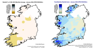
Rainfall % of 1981 – 2010 Monthly Average for January 2024 (Provisional) Total Monthly Rainfall (mm) for January 2024 (Provisional)
Temperature: Below average in most places
- Coldest January since 2011 at Moore Park, Co Cork and Valentia Observatory, Co Kerry.
- Coldest temperature of the month, -7.3 °C at Athenry, Co Galway was its lowest minimum temperature for January since 1994.
- Highest Temperature of the month, 15.4 °C at Belmullet, Co Mayo was its highest maximum temperature for January on record (length 67 years).
- Finner, Co Donegal also has its highest maximum temperature for January on record (record length 12 years).
- Four icing days* were reported during the month.
The majority of mean air temperatures across the country were below their LTA for the month. Deviations from mean air temperature ranged from -1.4 °C (4.3 °C mean temperature) at Moore Park, Co Cork (its coldest January since 2011) to 0.4 °C at both Phoenix Park, Co Dublin (5.3 °C mean temperature) and Finner, Co Donegal (5.5 °C mean temperature). Mean temperatures for the month ranged from 4.2 °C (0.1 °C above its LTA) at Knock Airport, Co Mayo to 6.7 °C (0.8 °C below its LTA) at Sherkin Island, Co Cork. The month’s lowest temperatures were recorded on Thursday 18th with the lowest air minimum reported at Athenry, Co Galway with a temperature of -7.3 °C (its lowest minimum for January since 1994) and the lowest grass minimum reported at Oak Park, Co Carlow with -13.3 °C. The highest maximum was reported on Sunday 28th at Belmullet, Co Mayo with a temperature of 15.4 °C (its highest maximum for January on record (length 67 years)). All stations reported air and ground frost during the month. The number of days with ground frost ranged from 10 days at both Dublin Airport and Malin Head, Co Donegal to 22 days at Moore Park, Co Cork. The number of days with air frost ranged from 1 day at Malin Head, Co Donegal to 15 days at both Moore Park, Co Cork and Mount Dillon, Co Roscommon. Valentia Observatory, Co Kerry also had its coldest January since 2011 with a mean temperature of 6.3 °C (1.0 below its LTA). Finner, Co Donegal also has its highest maximum temperature for January on record with 14.7 °C on Tuesday 23rd (record length 12 years). Four icing days* were reported during the month, three on Sunday 7th at Moore Park, Co Cork, Ballyhaise, Co Cavan and Gurteen, Co Tipperary and one ending on Thursday 18th at Gurteen.
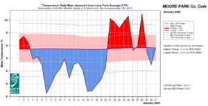
Moore Park, Co Cork Temperature: Daily mean departure from LTA for January 2024 based on 09-09hr Max/Min values.
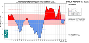
Dublin Airport, Co Dublin Temperature: Daily mean departure from LTA for January 2024 based on 09-09hr Max/Min values.
Sunshine: Above average everywhere
- Shannon Airport, Co Clare had its sunniest January on record (length 78 years).
- Dublin Airport, Co Dublin had its sunniest January day on record (length 82 years).
All available sunshine totals were above their LTA. Percentage of monthly sunshine values ranged from 131% (monthly sunshine total of 70.7 hours) at Casement Aerodrome, Co Dublin to 173% (monthly sunshine total of 87.9 hours) at Shannon Airport, Co Clare (its sunniest January on record (length 78 years)). Monthly sunshine totals ranged from 51.7 hours (No LTA comparison*) at Belmullet, Co Mayo to 94.6 hours (No LTA comparison*) at Cork Airport, Co Cork. The highest number of daily sunshine hours recorded this month was 8.2 hours at Dublin Airport on Tuesday 30th (its highest daily sunshine for January on record (length 82 years)). The number of dull days* ranged from 9 days at both Malin Head, Co Donegal and Valentia Observatory, Co Kerry to 15 days at Dublin Airport.
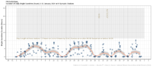
Hours of Bright Sunshine observed at each station for each day of the month, grouped by province relative to the highest number of hours possible by end of month (shaded box)
Wind: Violent storm force winds reported during storm Isha and storms force winds reported during storm Jocelyn
- Gales were reported on eleven days during the month.
- Strong gales were reported on seven days.
- Storm force winds were reported at five stations during storm Isha and at one station during storm Jocelyn.
- Violent storm force winds were reported at one station during storm Isha.
- Mace Head, Co Galway had its highest sustained mean wind speed for January on record (length 20 years).
Monthly mean wind speeds ranged from 5.6 knots (10.4 km/h) at Moore Park, Co Cork to 16.8 knots (31.1 km/h) at Malin Head, Co Donegal. Gales were reported on eleven days with strong gales reported on Sunday 21st, Monday 22nd, Tuesday 23rd, Wednesday 24th, Friday 26th, Sunday 28th and Wednesday 31st. Mean wind speeds reached storm force on Sunday 21st at five stations during storm Isha, Monday 22nd at one station during storm Isha and Tuesday 23rd at one station during storm Jocelyn, with up to violent storm force winds reported on Sunday 21st at one station during storm Isha. The number of days with gales ranged from zero days at a few stations to 9 days at Mace Head, Co Galway. The number of days with up to strong gales ranged from zero days at Dublin Airport to 4 days at both Mace Head, Co Galway and Malin Head, Co Donegal. The number of days with storms force winds were up to 2 days at both Mace Head, Co Galway and Malin Head, Co Donegal, with violent storm force winds reported on one day at Mace Head, Co Galway. Both the month’s highest gust and 10-minute mean wind speed was reported at Mace Head, Co Galway on Sunday 21st during storm Isha. The highest gust was 74 knots (137 km/h) while the month’s highest 10-minute mean wind speed was 57 knots (105 km/h) (its highest sustained mean wind speed for January on record (length 20 years).
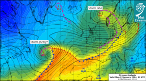
Airmass Analysis chart 12 UTC 22 January 2024: Storm Isha had passed and Storm Jocelyn approaches.
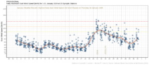
January 2024: Maximum Gust Wind Speeds (km/h) at each station for each day grouped by province and relative to their warning criteria and to their National Record
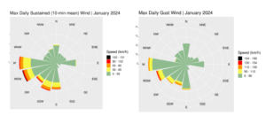
Wind roses for January 2024
The full report is available at https://www.met.ie/climate/past-weather-statements
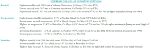
January 2024 extreme values at synoptic stations
*Issued by Met Éireann on Friday 2nd February 2024. This report is based on available preliminary data from 25 principal weather stations operated by Met Éireann. Synoptic station data is midnight to midnight UTC. Long-Term Averages (LTAs) and “average” refer to the period 1981-2010 unless stated. A wet day is a day with 1.0 mm or more of rainfall. A dull day is a day with less than 0.5 hours of sunshine. A very wet day is a day with 10.0 mm or more of rainfall. Climatological dry periods – An absolute drought is a period of 15 or more consecutive days to none of which is credited 0.2 mm or more of precipitation. A partial drought is a period of at least 29 consecutive days, the mean daily rainfall of which does not exceed 0.2 mm. A dry spell is a period of 15 or more consecutive days to none of which is credited 1.0 mm or more of precipitation (i.e. daily tot < 1.0 mm). A heatwave occurs where there are 5 consecutive days or more with maximum temperature over 25°C (that is, a daily maximum screen air temperature > 25° C). An icing day is when the daily maximum air temperature stays below 0 °C (measured from 09-09 UTC or 00-00 UTC). *Sunshine data is from the Autosol Network. LTAs for these sites are currently not used for comparison purposes. For more information, contact Met Éireann at 01-8064200 or e-mail: enq@met.ie