Winter (December 2023, January & February 2024)
Mild and wet overall with six named storms, cooler and drier January
The winter of 2023/2024 was the eleventh consecutive season with above average temperatures. December and February were mild and wet while January was cool and dry overall. December started dry and cool before Atlantic low pressure took control and dominated for the rest of the month. Storm Elin and storm Fergus, both named by Met Éireann, crossed directly over the country on Saturday 9th and Sunday 10th. Storm Gerrit, named by the UK Met Office, and storm Geraldine, named by Météo-France, brought periods of wet and windy weather during the final week of the month. The first two thirds of January were cold and relatively dry with high pressure to the north in charge. The final third of the month saw Atlantic low pressure take control. An intense North Atlantic jet stream steered two named storms, Isha named by the Met Office (UK) and Jocelyn named by Met Éireann, close to the north of the country between the 21st and 24th, which brought the windiest period of the season. February was an Atlantic dominated month with low pressure in control. Numerous bands of rain or showers crossed the country in a mostly mild west to south-westerly airflow. This brought record high monthly mean temperatures to the Southwest of the country with above average rainfall for most.
Rainfall: Above average in most places, wettest in the West
Nearly all rainfall totals were above their Long-Term Average 1981-2010 (LTA) for the season. Percentage of rainfall values ranged from 96% (seasonal rainfall total of 348.3 mm) at Sherkin Island, Co Cork to 139% (seasonal rainfall total of 454.5 mm) at Athenry, Co Galway. Seasonal rainfall totals ranged from 200.5 mm (104% of its LTA) at Phoenix Park, Co Dublin to 617.0 mm (130% of its LTA) at Newport, Co Mayo. The highest daily rainfall total was 36.4 mm at Johnstown Castle, Co Wexford on Thursday 8th February. The number of rain days ranged from 52 days at Dublin Airport, Co Dublin to 82 days at both Newport, Co Mayo and Belmullet, Co Mayo. The number of wet days* ranged from 35 days at Phoenix Park. Co Dublin to 68 days at Belmullet, Co Mayo. The number of very wet days* ranged from 4 days at both Dublin Airport and Casement Aerodrome, Co Dublin to 27 days at Newport, Co Mayo. In January nine stations in the Midlands, South and East had dry spells* lasting between 16 and 17 days and one station had an absolute drought* lasting 16 consecutive days (see January climate statement for more details).
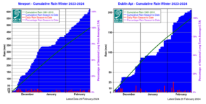
Newport, Co Mayo – Cumulative Rain Winter 2023-2024 Dublin Airport – Cumulative Rain Winter 2023-2024
Temperature: Above average everywhere
- Eleventh consecutive season with above average temperatures at most stations.
All mean air temperatures across the country were above their LTA for the season. Deviations from mean air temperature ranged from 0.7 °C (6.2 °C mean temperature) at Markree, Co Sligo to 1.7 °C (6.9 °C mean temperature) at Phoenix Park, Co Dublin. Mean temperatures for the season ranged from 5.5 °C (1.4 °C above its LTA) at Knock Airport, Co Mayo to 8.5 °C (0.8 °C above its LTA) at Sherkin Island, Co Cork. The season’s lowest temperatures were recorded on Thursday 18th January with the lowest air minimum reported at Athenry, Co Galway with a temperature of -7.3 °C and the lowest grass minimum reported at Oak Park, Co Carlow with -13.3 °C. The highest maximum was reported on Sunday 28th January at Belmullet, Co Mayo with a temperature of 15.4 °C. All stations reported air and ground frost during the season. The number of days with ground frost ranged from 19 days at both Roche’s Point, Co Cork and Malin Head, Co Donegal to 50 days at Mount Dillon, Co Roscommon. The number of days with air frost ranged from 3 days at Malin Head, Co Donegal to 24 days at Mount Dillon, Co Roscommon. Dublin Airport had its warmest winter since 1992 with a mean temperature of 6.6 °C (1.2 °C above its LTA).
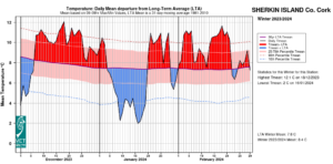
Sherkin Island, Co Cork Temperature: Daily mean departure from LTA for Winter 2023-2024 based on 09-09hr Max/Min values.
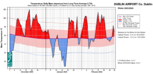
Dublin Airport, Co Dublin Temperature: Daily mean departure from LTA for Winter 2023-2024 based on 09-09hr Max/Min values.
Sunshine: Above average, sunniest in the South
All available sunshine totals were above their LTA for the season. Percentage of seasonal sunshine values ranged from 101% (seasonal sunshine total of 175.0 hours) at Casement Aerodrome, Co Dublin to 118% (seasonal sunshine total of 191.5 hours) at Shannon Airport, Co Clare. Seasonal sunshine totals ranged from 138.4 hours (No LTA comparison*) at Belmullet, Co Mayo to 231.2 hours (No LTA comparison*) at Cork Airport, Co Cork. The highest number of daily sunshine hours recorded this season was 9.5 hours at Johnstown Castle, Co Wexford on Monday 26th February (its highest daily sunshine for winter on record (length 15 years)). The number of dull days* ranged from 33 days at Shannon Airport, Co Clare to 41 days at Valentia Observatory, Belmullet and Casement Aerodrome, Co Dublin.
Wind: Violent storm force winds reported, with six named storms directly affecting Ireland
Seasonal mean wind speeds ranged from 6.4 knots (11.9 km/h) at Moore Park, Co Cork to 17.4 knots (32.2 km/h) at Malin Head, Co Donegal. Storm force winds were reported on Sunday 10th December during storm Fergus, Sunday 21st January and Monday 22nd January during storm Isha and Tuesday 23rd January during storm Jocelyn. Up to violent storm force winds were reported on Sunday 21st January at Mace Head, Co Galway during storm Isha. There were numerous days with gales and strong gales (see individual monthly statements for more details). The number of days with up to strong gales ranged from zero days at most stations to 9 days at Malin Head, Co Donegal. The number of days with storm force winds were up to 3 days at Mace Head, Co Galway. Both the season’s highest gust and 10-minute mean wind speed was reported at Mace Head, Co Galway on Sunday 21st January during storm Isha. The highest gust was 74 knots (137 km/h) while the season’s highest 10-minute mean wind speed was 57 knots (105 km/h).
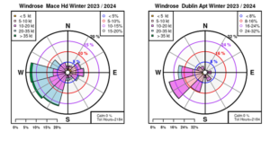
Mace Head, Co Galway and Dublin Airport, Co Dublin: Wind Roses for Winter 2023-2024
The full report is available here (choose Winter on drop down menu for month) or the PDF is available here
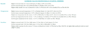
Winter 2023-2024 extreme values at synoptic stations
February
Mild and wet
February 2024 was a mild Atlantic dominated month. The first week saw low pressure to the north and high pressure to the south steer a relatively dry and mild westerly airflow across the country initially. An active cold front brought widespread rain on Tuesday 6th as it crossed the country from the northwest, introducing a cooler Polar maritime air mass. Further active weather fronts pushed up from the south into the cooler air mass at the beginning of the second week, giving widespread heavy rain with some wintry falls in the Northwest. Low pressure remained in charge for the rest of the second week, bringing bands of rain or showers across the country at times, along with a few drier and sunnier days. Low pressure centred to the west and north of Ireland, remained in control for the third week and brought a mild south-westerly airflow. Several frontal rain bands crossed the country giving widespread rain at times, heaviest in the West. The fourth week was cooler as another Polar maritime air mass swept over the country from the northwest on Thursday 22nd. This brought several cool and showery days, with the heaviest of the showers in the West, which turned wintry at times. A deep area of Low pressure passed south of Ireland from west to east on Sunday 25th bringing a spell of heavy rain to the South. Low pressure stayed in control up to the end of the month with further bands of rain or showers crossing the country in a westerly airflow.
Rainfall: Above average nearly everywhere
- The highest daily rainfall total of 36.4 mm at Johnstown Castle, Co Wexford on Thursday 8th was its highest daily fall for February on record (length 21 years).
- Nine stations had over 150% of their February LTA rainfall and two stations in the Southwest had over 200% of their February LTA rainfall.
The majority of monthly rainfall totals were above their 1981-2010 Long-Term Average (LTA). Percentage of monthly rainfall values ranged from 87% (monthly rainfall total of 83.0 mm) at Finner, Co Donegal to 222% (monthly rainfall total of 166.1 mm) at Roche’s Point, Co Cork. Monthly rainfall totals ranged from 64.9 mm (134% of its LTA) at Casement Aerodrome, Co Dublin to 197.5 mm (156% of its LTA) at Newport, Co Mayo. The highest daily rainfall total was 36.4 mm at Johnstown Castle, Co Wexford on Thursday 8th (its highest daily fall for February on record (length 21 years)). The number of rain days ranged from 18 days at Dublin Airport, Co Dublin to 29 days at Malin Head, Co Donegal. The number of wet days* ranged from 12 days at both Phoenix Park, Co Dublin and Dublin Airport to 25 days at Valentia Observatory, Co Kerry. The number of very wet days* ranged from 1 day at a few stations to 8 days at Newport, Co Mayo.
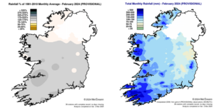
Rainfall % of 1981 – 2010 Monthly Average for February 2024 (Provisional) Total Monthly Rainfall (mm) for February 2024 (Provisional)
Temperature: Above average everywhere, highest in the Southwest
- Seven stations had their warmest February on record, including five station in the Southwest (record lengths from 19 to 84 years).
- According to the Island of Ireland long-term temperature series*, which uses observations measured between 09 and 09 UTC (from 1900 to date), Valentia Observatory, Co Kerry with a mean temperature of 9.25 °C had its warmest February on record in this 125-year data series. The previous warmest February’s were in 1961 with 9.20 °C and 2019 with 9.19 °C.
- Sherkin Island, Co Cork with a mean temperature of 9.3°C (1.8°C above its LTA) is its warmest February on record (length 49 years) and the warmest February at any station on record since 1941 (between 00 and 00 UTC)
- Five other stations in the Midlands and East, including Dublin Airport, Mullingar, Co Westmeath and Johnstown Castle, Co Wexford, had their warmest February since 1998.
- Nine stations had their highest minimum for February on record (record lengths range from 8 to 49 years).
All mean air temperatures across the country were above their LTA for the month. Deviations from mean air temperature ranged from 1.4 °C (7.2 °C mean temperature) at Malin Head, Co Donegal to 2.5 °C (8.3 °C mean temperature) at Moore Park, Co Cork (its warmest February on record (length 55 years)). Mean temperatures for the month ranged from 6.4 °C (2.2 °C above its LTA) at Knock Airport, Co Mayo to 9.3 °C at Sherkin Island, Co Cork (1.8 °C above its LTA) (its warmest February on record (length 49 years)). Both the month’s highest and lowest air temperatures were recorded at Moore Park, Co Cork. The lowest minimum was reported on Monday 12th with a temperature of -2.2 °C while the highest maximum was reported on Sunday 4th and Wednesday 21st with a temperature of 14.7 °C. The lowest grass minimum was reported at Oak Park, Co Carlow on Thursday 1st with -6.6 °C. All stations reported ground frost during the month. The number of days with ground frost ranged from 2 days at both Mace Head, Co Galway and Belmullet, Co Mayo to 20 days at Phoenix Park, Co Dublin. Less than half of stations reported air frost. The number of days with air frost ranged from zero days at Phoenix Park, Co Dublin to 3 days at both Markree, Co Sligo and Mount Dillon, Co Roscommon. Along with Sherkin Island and Moore Park, five other stations had their warmest February on record (record lengths range from 19 to 84 years). These were Cork Airport, Co Cork with a mean temperature of 8.0 °C (2.4 °C above its LTA), Roches Point, Co Cork with 8.9 °C (2.0 °C above its LTA), Oak Park, Co Carlow with 7.8 °C (2.2 °C above its LTA), Mount Dillon, Co Roscommon with 7.3 °C (2.3 °C above its LTA) and Valentia Observatory, Co Kerry with 9.2 °C (2.01 °C above its LTA). Five other stations in the Midlands and East, including Dublin Airport, Mullingar, Co Westmeath and Johnstown Castle, Co Wexford, had their warmest February since 1998. Nine stations had their highest minimum for February on record (record lengths range from 8 to 49 years).
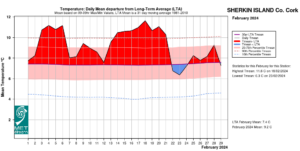
Sherkin Island, Co Cork Temperature: Daily mean departure from LTA for February 2024 based on 09-09hr Max/Min values.
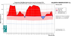
Valentia Observatory, Co Kerry Temperature: Daily mean departure from LTA for February 2024 based on 09-09hr Max/Min values.
Sunshine: Highest in the Southeast
Percentage of LTA sunshine values were variable (where available) across the country. Percentage of monthly sunshine values ranged from 89% (monthly sunshine total of 63.0 hours) at Casement Aerodrome, Co Dublin to 92% (monthly sunshine total of 60.4 hours) at Shannon Airport, Co Clare. Monthly sunshine totals ranged from 51.4 hours (No LTA comparison*) at Valentia Observatory, Co Kerry to 75.5 hours (No LTA comparison*) at Johnstown Castle, Co Wexford. The highest number of daily sunshine hours recorded this month was 9.5 hours at Johnstown Castle, Co Wexford on Monday 26th (its highest daily sunshine for February on record (length 15 years)). The number of dull days* ranged from 10 days at a few stations to 13 days at Valentia Observatory, Co Kerry.
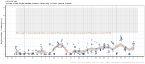
Hours of Bright Sunshine observed at each station for each day of the month, grouped by province relative to the highest number of hours possible by end of month (shaded box)
Wind: Strong gales reported
Monthly mean wind speeds ranged from 5.8 knots (10.7 km/h) at Moore Park, Co Cork to 16.9 knots (31.3 km/h) at Malin Head, Co Donegal. Gales were reported on the 4th, 5th, 8th, 9th, 22nd, 28th and 29th with up to strong gale winds reported on Thursday 8th and Friday 9th. The number of days with gales ranged from zero days at most stations to 4 days at Malin Head, Co Donegal. The number of days with up to strong gales ranged from zero days at most stations to 2 days at Malin Head, Co Donegal. Both the month’s highest gust and 10-minute mean wind speed was reported at Malin Head, Co Donegal. The highest gust was on Thursday 29th with 57 knots (106 km/h) while the month’s highest 10-minute mean wind speed was 43 knots (80 km/h) on Thursday 8th.
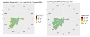
Wind roses for February 2024
The full report is available at https://www.met.ie/climate/past-weather-statements
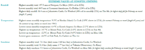
February 2024 extreme values at synoptic stations
*Issued by Met Éireann on Thursday 4th January 2024. This report is based on available preliminary data from 25 principal weather stations operated by Met Éireann. Synoptic station data is midnight to midnight UTC. Long-Term Averages (LTAs) and “average” refer to the period 1981-2010 unless stated. A wet day is a day with 1.0 mm or more of rainfall. A dull day is a day with less than 0.5 hours of sunshine. A very wet day is a day with 10.0 mm or more of rainfall. Climatological dry periods – An absolute drought is a period of 15 or more consecutive days to none of which is credited 0.2 mm or more of precipitation. A partial drought is a period of at least 29 consecutive days, the mean daily rainfall of which does not exceed 0.2 mm. A dry spell is a period of 15 or more consecutive days to none of which is credited 1.0 mm or more of precipitation (i.e. daily tot < 1.0 mm). A heatwave occurs where there are 5 consecutive days or more with maximum temperature over 25°C (that is, a daily maximum screen air temperature > 25° C). The Island of Ireland dataset is 125 years long and runs between 1900 and 2023. For this dataset the long term averages from the 1961-1990 reference period are used for comparison as is standard for long-term climate change assessments. *Sunshine data is from the Autosol Network. LTAs for these sites are currently not used for comparison purposes. For more information, contact Met Éireann at 01-8064200 or e-mail: enq@met.ie