Summer 2023 (June, July & August)
Hot June, wet July, stormy August
Summer 2023 saw the warmest June on record on land and at sea, the wettest July on record with 17 stations having over 200% of their Long-Term Average (LTA) monthly rainfall and finished with two named storms in August that downed trees and caused flash and coastal flooding. The season began very dry with widespread climatological dry periods* up to mid-June, before breaking down with eight consecutive days of intense thunderstorm activity. Atlantic westerlies took hold towards the end of June. July saw Atlantic low pressure systems dominating in a mostly westerly or cyclonic airflow. Ireland lay on the cooler northern side of the North Atlantic jet stream for most of the month, which was relatively strong for the time of year. Numerous active weather fronts crossed the country along with periods of in-tense, sometimes thundery, convective rainfall. August was again dominated by Atlantic low pressure systems. Two named storms, storm Antoni at the beginning of the month, named by the UK Met Office and storm Betty just after mid-month, named by Met Éireann, were the significant weather events of the month. They brought spells of very heavy rain and strong winds causing coastal and flash flooding and brought down numerous trees in the East of the country.
Summer 2023 was provisionally the 5th warmest summer on record for the island of Ireland (record length 124 years) and only marginally below the Summer of 2018. The four warmest summers were 1995, 1976, 2006 and 2018. The high mean temperatures this summer were driven by the record hottest June and high night-time temperatures throughout the summer months.
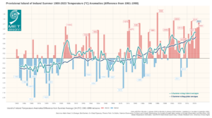
Provisional Island of Ireland Summer 1900-2023 Temperature Anomalies (difference from 1961-1990)
Rainfall: Above average everywhere, wettest in July, driest in June
All rainfall totals were above their 1981-2010 Long-Term Average (LTA) for the season. Percentage of seasonal rainfall values ranged from 114% (seasonal rainfall total of 260.7 mm) at Johnstown Castle, Co Wexford to 170% (seasonal rainfall total of 401.6 mm) at Mount Dillon, Co Roscommon. Seasonal rainfall totals ranged from 252.9 mm (132% of its LTA) at Oak Park, Co Carlow to 471.9 mm (153% of its LTA) at Valentia Observatory, Co Kerry. The season’s wettest day was also recorded at Valentia Observatory, Co Kerry with 74.0 mm on Friday 18th August (its highest daily fall in summer since 1986). The number of rain days ranged from 52 days at Roche’s Point, Co Cork to 75 days at both Markree, Co Sligo and Knock Airport, Co Mayo. The number of wet days* ranged from 34 days at Johnstown Castle, Co Wexford to 64 days at Athenry, Co Galway. The number of very wet days* ranged from 7 days at a few stations to 17 days at Knock Airport, Co Mayo. Dublin Airport, Co Dublin had its wettest summer since 2008 with 318.0 mm (162% of its LTA) and Knock Airport, Co Mayo had its wettest summer since 2012 with 435.2 mm (147% of its LTA). 24 stations had absolute droughts* between Monday 15th May and Sunday 11th June lasting between 17 and 26 days, longest in the South and East. Malin Head, Co Donegal had a dry spell* between May 21st and June 16th lasting 27 days. Seven stations had partial droughts* between Thursday 11th May and Friday 16th June lasting between 29 and 36 days, longest in the South and East.
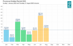
Provisional monthly gridded 2023 rainfall (%) for Ireland on a monthly basis. Provisionally 8th wettest summer since 1941
Temperature: Above average everywhere, warmest in the Northwest
All mean air temperatures across the country were above their LTA for the season. Deviations from mean air temperature for the season ranged from 0.5 °C (15.5 °C mean temperature) at Sherkin Island, Co Cork to 1.5 °C (15.8 °C mean temperature) at Belmullet, Co Mayo. Mean temperatures for the season ranged from 14.6 °C (1.3 °C above its LTA) at Knock Airport, Co Mayo (its warmest summer on record, length 26 years) to 16.5 °C (0.9 °C above its LTA) at Shannon Airport, Co Clare. The season’s highest temperature was reported at Oak Park, Co Carlow on Tuesday 13th June with a temperature of 28.8 °C. Both the season’s lowest air and grass minimum temperatures were recorded on Saturday 3rd June at Mount Dillon, Co Roscommon. The lowest air minimum was 2.1 °C while the lowest grass minimum was -3.2 °C. There was no air frost reported this season. Less than half of stations reported ground frost. The number of days with ground frost ranged from zero days at most stations to 6 days at Mount Dillon, Co Roscommon. Along with Knock Airport, Malin Head, Co Donegal also had its warmest summer on record with a mean temperature of 15.1 °C (1.3 °C above its LTA) (record length 69 years). Athenry, Co Galway had its warmest summer since 1983 with a mean temperature of 15.7 °C (0.8 °C above its LTA) and both Valentia Observatory, Co Kerry 15.9 °C (1.1 °C above its LTA) and Claremorris, Co Mayo 15.4 °C (1.2 °C above its LTA) had their warmest summer since 1995. Three stations had their highest minimum temperature for summer on record and 14 stations had their highest mean minimum temperature for summer on record.
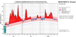
Malin Head, Co Donegal Temperature: Daily mean departure from LTA for Summer 2023 based on 09-09hr Max/Min values. 2023 is Malin head’s warmest summer on record (record length 69 years)
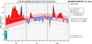
Shannon Airport, Co Clare Temperature: Daily mean departure from LTA for Summer 2023 based on 09-09hr Max/Min values.
Sunshine: Above average, sunniest in the North
All available sunshine totals were above their LTA for the season. Percentage of seasonal sunshine values ranged from 112% (seasonal sunshine total of 518.7 hours) at Casement Aerodrome, Co Dublin to 113% (seasonal sunshine total of 495.2 hours) at Shannon Airport, Co Clare. Seasonal sunshine totals ranged from 410.5 hours (No LTA comparison*) at Valentia Observatory, Co Kerry to 527.8 hours (No LTA comparison*) at Malin Head, Co Donegal. The highest number of daily sunshine hours recorded this season was 16.0 hours at Malin Head, Co Donegal on Friday 9th and Thursday 15th June. The number of dull days* ranged from 4 days at Casement Aerodrome, Co Dublin to 18 days at Valentia Observatory, Co Kerry.
Wind: Strong gales reported in August during storm Antoni and gales during storm Betty
Seasonal mean wind speeds ranged from 5.3 knots (9.8 km/h) at Ballyhaise, Co Cavan to 13.7 knots (25.4 km/h) at Mace Head, Co Galway. Gales were reported on Saturday 8th July. Gales were reported on Friday 18th and Saturday 19th during storm Betty with up to strong gale winds reported on Saturday 5th during storm Antoni. The number of days with gales ranged from zero days at most stations to 2 days at Malin Head, Co Donegal. The number of days with up to strong gales ranged from zero at most stations to 1 day at Roche’s Point, Co Cork. Both the season’s highest gust and 10-minute mean wind speed was reported at Roche’s Point, Co Cork on Saturday 5th August during storm Antoni. The highest gust was 55 knots (102 km/h) while the season’s highest 10-minute mean wind speed was 43 knots (80 km/h). During storm Betty, Dunsany, Co Meath had its highest gust for August on record with 40 knots (74 km/h) late on Friday 18th (record length 17 years) and Dublin Airport, Co Dublin had its highest gust for August since 1988 with 47 knots (87 km/h) early on Saturday 19th.
The full report is available here (choose Summer on drop down menu for month) or the PDF is available here
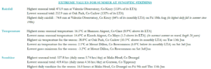
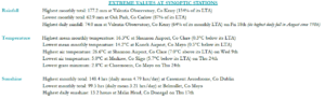
Summer 2023 extreme values at synoptic stations
August 2023
Mild and changeable, two named storms
August 2023 was dominated by Atlantic low pressure systems. Two named storms, storm Antoni, named by the UK Met Office and storm Betty, named by Met Éireann, were the significant weather events of the month. The first week saw two low pressure systems crossing the south of the country from west to east, bringing bands of rain or showers. The second more active low pressure system, named storm Antoni, crossed the country on the 4th and 5th. This brought a period of very heavy rain to the northern half of the country, causing some flooding, with the strongest winds confined mostly to the South. The second week saw low pressure to the west and northwest of Ireland bringing further bands of rain or showers across the country, interspersed with drier and sunnier periods. A transient area of high pressure brought a few mostly dry days at the beginning of the third week, before storm Betty, developed to the southwest of Ireland and moved rapidly towards the country on Friday 18th. This brought widespread heavy rain and strong winds, with embedded thunderstorm activity causing some flash flooding. The centre of the storm crossed the country from south to north in the early hours of Saturday 19th causing some coastal flooding and downing numerous trees, especially in the South and East. The rest of the month saw low pressure to the north of Ireland, bringing further bands of rain or showers, sometimes thundery, interspersed with drier sunnier periods.
Rainfall: Above average in most places, wettest in the Northeast and Southwest
The majority of monthly rainfall totals were above their 1981-2010 Long-Term Average (LTA). Percentage of monthly rainfall values ranged from 78% (monthly rainfall total of 92.2 mm) at Mace Head, Co Galway to 163% (monthly rainfall total of 119.4 mm) at Dublin Airport, Co Dublin. Monthly rainfall totals ranged from 62.9 mm (87% of its LTA) at Oak Park, Co Carlow to 177.2 mm (154% of its LTA) at Valentia Observatory, Co Kerry. The month’s wettest day was on Friday 18th during storm Betty. The highest daily fall was recorded at Valentia Observatory, Co Kerry with 74.0 mm (its highest daily fall in August since 1986). Also on Friday 18th, Roches Point, Co Cork had its highest daily fall for August on record with 59.6 mm (record length 19 years) and Cork Airport, Co Cork has its highest daily fall for August since 1998 with 63.0 mm. The number of rain days ranged from 15 days at Casement Aerodrome, Co Dublin to 29 days at Newport, Co Mayo. The number of wet days* ranged from 12 days at Phoenix Park, Co Dublin to 22 days at a few stations. The number of very wet days* ranged from 1 day at a few stations to 6 days at Knock Airport, Co Mayo.
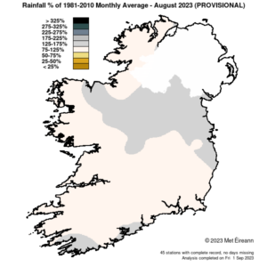
Rainfall % of 1981 – 2021 Monthly Average for August 2023 (Provisional)
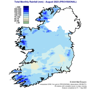
Total Monthly Rainfall (mm) for August 2023 (Provisional)
Temperature: Above average nearly everywhere
Nearly all mean air temperatures were above their LTA for the month. Deviations from mean air temperature ranged from -0.1 °C (15.6 °C mean temperature) at Sherkin Island, Co Cork to 0.9 °C (15.6 °C, 15.7 °C, 16.1 °C mean temperature) at Gurteen, Co Tipperary, Belmullet, Co Mayo and Phoenix Park, Co Dublin respectively. Mean temperatures for the month ranged from 14.2 °C (0.5 °C above its LTA) at Knock Airport, Co Mayo to 16.3 °C (0.3 °C above its LTA) at Shannon Airport, Co Clare. The month’s lowest temperatures were recorded on Thursday 24th with the lowest air minimum of 5.0 °C reported at Markree, Co Sligo (5.7 below its LTA) and the lowest grass minimum reported at Claremorris, Co Mayo with 2.8 °C. The highest maximum was reported on Wednesday 9th at Shannon Airport, Co Clare with a temperature of 26.6 °C (7.0°C above its LTA) . There was no air or ground frost reported this month.
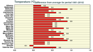
August 2023 temperature difference from the 1981-2010 LTA at synoptic stations
Sunshine: Below average in most places
Nearly all available sunshine totals were below their LTA. Percentage of monthly sunshine values ranged from 98% (the highest monthly sunshine total of 148.4 hours) at Casement Aerodrome, Co Dublin to 101% (monthly sunshine total of 142.5 hours) at Shannon Airport, Co Clare. Monthly sunshine totals were lowest at Belmullet, Co Mayo with 99.5 hours (No LTA comparison*). The highest number of daily sunshine hours recorded this month was 13.2 hours at Malin Head, Co Donegal on Thursday 17th. The number of dull days* ranged from 2 days at a few stations to 5 days at both Shannon Airport, Co Clare and Valentia Observatory, Co Kerry.
Wind: Strong gales reported and two named storms
Monthly mean wind speeds ranged from 5.6 knots (10.4 km/h) at Ballyhaise, Co Cavan to 14.4 knots (26.7 km/h) at Malin Head, Co Donegal. Gales were reported on Friday 18th and Saturday 19th during storm Betty with up to strong gale winds reported on Saturday 5th during storm Antoni. The number of days with gales ranged from zero days at most stations to 2 days at Malin Head, Co Donegal. The number of days with up to strong gales ranged from zero days at most stations to 1 day at Roche’s Point, Co Cork. Both the month’s highest gust and 10-minute mean wind speed was reported at Roche’s Point, Co Cork on Saturday 5th during storm Antoni. The highest gust was 55 knots (102 km/h) while the month’s highest 10-minute mean wind speed was 43 knots (80 km/h). During storm Betty, Dunsany, Co Meath had its highest gust for August on record with 40 knots (74 km/h) late on Friday 18th (record length 17 years) and Dublin Airport, Co Dublin had its highest gust for August since 1988 with 47 knots (87 km/h) early on Saturday 19th.
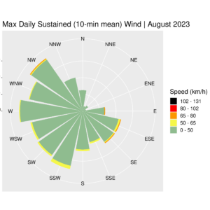
Wind rose for Ireland Max Daily Sustained (10-min mean) August 2023 (provisional)
The full report is available here
August 2023 extreme values at synoptic stations
Recent Augusts in Ireland:
- 2016: Two-thirds of stations reported below Long-Term Average (LTA) rainfall for August. Nearly all stations reported mean air temperatures above LTA. Sunshine values were mainly below average and gales were reported.
- 2017: Percentage of LTA rainfall values were variable. All stations reported mean air temperatures below their LTA. Nearly all available sunshine totals were below average and gales were reported.
- 2018: The majority of monthly rainfall totals across the country were below their LTA. Mean temperatures were variable. Sunshine totals were below everywhere.
- 2019: The majority of monthly rainfall totals were above their LTA. Nearly all mean air temperatures and sunshine totals across the country were above average. Active thunderstorm activity and strong gales were reported during the month.
- 2020: The majority of monthly rainfall totals and mean air temperatures were above their LTA. Sunshine totals were below average everywhere. Two named storms, Ellen and Francis occurred. Record-breaking violent storm force 11 winds and a new low mean sea level pressure record for August (966.4 hPa) was recorded during Storm Ellen.
- 2021: The majority of monthly rainfall totals were below their LTA. Nearly all mean air temperatures were above average while sunshine totals varied. Gales were reported.
- 2022: All monthly rainfall totals were below their LTA. All mean air temperatures and all sunshine totals were above average with record-high maximum daily temperatures reported at eleven stations.
*Issued by Met Éireann on Monday 4th September 2023. This report is based on available preliminary data from 25 principal weather stations operated by Met Éireann. Synoptic station data is midnight to midnight UTC. Long-Term Averages (LTAs) and “average” refer to the period 1981-2010. A wet day is a day with 1.0 mm or more of rainfall. A dull day is a day with less than 0.5 hours of sunshine. A very wet day is a day with 10.0 mm or more of rainfall. Climatological dry periods – An absolute drought is a period of 15 or more consecutive days to none of which is credited 0.2 mm or more of precipitation. A partial drought is a period of at least 29 consecutive days, the mean daily rainfall of which does not exceed 0.2 mm. A dry spell is a period of 15 or more consecutive days to none of which is credited 1.0 mm or more of precipitation (i.e. daily tot < 1.0 mm). A heatwave occurs where there are 5 consecutive days or more with maximum temperature over 25°C (that is, a daily maximum screen air temperature > 25° C). *Sunshine data is from the Autosol Network. LTAs for these sites are currently not used for comparison purposes. For more information, contact Met Éireann at 01-8064200 or e-mail: enq@met.ie