Summer 2022 (June, July, August)
Dry and warm, sunny in the South and East
Summer 2022 is the fifth consecutive season where every synoptic station recorded above average mean temperatures. New high maximum daily temperature records were set for July and August, which were also very dry months, following a wetter than average June. It was sunny in the South and East and dull in the North and Northwest. June was a relatively mild, Atlantic dominated month, with the airflow mostly between southerly and westerly. This kept it wetter, cooler and cloudier in the West and drier, warmer and sunnier in the East. July and August saw the Azores high pressure building up over Ireland on a number of occa-sions bringing mostly warmer and drier conditions. An exceptionally hot tropical continental air mass moved up over Ireland and the UK from the south-southeast between Sunday 17th and Tuesday 19th of July, which brought record high maximum daily temperatures at nine synoptic stations including a new all-time record maximum daily temperature for July. Heatwave conditions in August between Tuesday 9th and Sunday 14th saw another record-breaking spell, with eleven synoptic stations breaking their August maximum daily temperature records including a new all-time record maximum daily temperature for August.
Rainfall: Below average everywhere, driest in the South and East
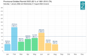
All seasonal rainfall totals across the country were below their 1981-2010 Long-Term Average (LTA) for summer. Percentage of seasonal rainfall values ranged from 49% (seasonal rainfall total of 126.4 mm) at Cork Airport, Co Cork to 96% (the season’s highest seasonal rainfall total of 311.3 mm) at Newport, Co Mayo. Seasonal rainfall totals were lowest at Dublin Airport, Co Dublin with 108.4 mm (percentage of LTA 55%). The season’s wettest day was also recorded at New-port, Co Mayo with 47.5 mm on Monday 1st Aug. The number of rain days ranged from 27 days at Oak Park, Co Carlow to 62 days at Malin Head, Co Donegal. The number of wet days ranged from 19 days at Oak Park, Co Carlow to 40 days at Newport, Co Mayo. The number of very wet days ranged from 1 day at Phoenix Park, Co Dublin to 9 days at a few stations. Six stations had dry spells between 2nd and 22nd July lasting between 17 and 21 days and two stations had dry spells between 3rd and 19th August (more details on the dry spells in the monthly climate statements).
Provisional monthly gridded 2022 rainfall (%) for Ireland on a monthly basis.
Temperature: Above average everywhere, with ten stations breaking their all-time maximum daily temperature records
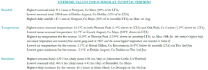
All mean air temperatures across the country were above their LTA for the season. Deviations from mean air temperature ranged from 0.2 °C (14.5 °C mean temperature) at Markree, Co Sligo to 1.3 °C (16.1 °C the season’s highest mean temperature) at Phoenix Park, Co Dublin. Mean temperatures for the season were lowest at Knock Airport, Co Mayo with 14.1 °C (difference from LTA 0.8 °C). The season’s lowest temperatures were recorded on Thursday 2nd June. The low-est air minimum reported at Mount Dillon, Co Roscommon with a temperature of 2.1 °C and the lowest grass minimum was reported at Dublin Airport, Co Dublin with -2.1 °C. The highest maximum was reported on Monday 18th Jul at Phoenix Park, Co Dublin with a temperature of 33.0 °C (the station’s highest daily maximum temperature ever recorded from records going back to 1881 and the second highest temperature ever recorded in Ireland). There was no air frost reported this season. Less than half of stations reported ground frost. The number of days with ground frost ranged from zero days at a few stations to 5 days at Mount Dillon, Co Roscom-mon. Heatwaves were reported at seven synoptic stations between Tuesday 9th and Sunday 14th August lasting between 5 and 6 days. Ten stations broke their all-time maximum daily temperature records. These were Phoenix Park, Co Dublin with 33.0 °C (record length 141 years), Casement Aerodrome, Co Dublin with 31.9 °(length 58 years), Mount Dillon, Co Roscommon with 31.4 °C (length 14 years), Gurteen, Co Tipperary with 31.0 °C (length 14 years), Ballyhaise, Co Cavan with 30.8 °C (length 17 years), Moore Park, Co Cork with 30.6 °C (length 35 years) (in August), Athenry, Co Galway (length 12 years) and Dunsany, Co Meath (length 48 years) with 30.5 °C, Mullingar, Co Westmeath with 30.4 °C (length 72 years) and Dublin Airport, Co Dublin with 29.6 °C (length 80 years). A number of stations also broke their July and/or August maximum temperature records (more details in the monthly climate statements).
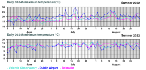
Daily summer 2022 max min temperatures for Valentia Observatory, Dublin Airport and Belmullet
Sunshine: Sunniest in August, especially in the South and East
All available sunshine totals were above their LTA for the season. Percentage of seasonal sunshine values ranged from 116% (seasonal sunshine total of 506.2 hours) at Shannon Airport, Co Clare to 120% (seasonal sunshine total of 558.2 hours) at Casement Aerodrome, Co Dublin. Seasonal sunshine totals were highest at Johnstown Castle, Co Wexford with 629.2 hours (no LTA comparison*). Seasonal sunshine totals were lowest at Belmullet, Co Mayo with 405.6 hours (no LTA comparison*). The highest number of daily sunshine hours recorded this season was 16.1 hours at Malin Head, Co Donegal on Saturday 4th Jun. The num-ber of dull days ranged from 9 days at Dublin Airport, Co Dublin to 17 days at Belmullet, Co Mayo.
Wind: Gales reported in June, no gales in July and August
Seasonal mean wind speeds ranged from 5.0 knots (9.3 km/h) at Ballyhaise, Co Cavan to 12.4 knots (23.0 km/h) at Mace Head, Co Galway. Gales were reported at Belmullet, Co Mayo on Friday 10th June and at Mace Head, Co Galway on Saturday 25th June. There were no gales in July and August. The number of days with gale force winds ranged from zero at most stations to 1 day at both Mace Head, Co Galway and Belmullet, Co Mayo. There were no strong gales or storms reported this season. The season’s 10-minute mean wind speed was reported at both Mace Head, Co Galway and Belmullet, Co Mayo on Saturday 25th June Friday 10th June respectively with 34 knots (63 km/h). The highest gust was 45 knots (83 km/h) reported at Belmullet, Co Mayo on Friday 10th Jun.
The full report is available here
Extreme values for summer 2022 at synoptic stations
————————————————————————————————————————————————————————————————————————————–
Recent Augusts in Ireland:
- 2016: Two-thirds of stations reported below Long-Term Average (LTA) for rainfall, nearly all stations were above mean temperatures and sunshine totals were mainly below average.
- 2017: Cool and dull. LTA rainfall values were variable, all air temperatures were below average and nearly all sunshine totals were below.
- 2018: Cooler & wetter in the North & West, drier & warmer elsewhere. Most monthly rainfall totals were below their LTA, mean air temperatures were variable and all stations had below average Sunshine totals.
- 2019: Mild and Unsettled. Above average rainfall totals, air temperatures and sunshine totals in most places.
- 2020: Warm, wet, and stormy. Storm Ellen and Francis brought heavy rainfall and gales. Rainfall and air temperatures were above average nearly everywhere while sunshine totals were below their LTA.
- 2021: Mild and changeable, dry finish. Most monthly rainfall totals were below their LTA, nearly all mean temperatures were above, and sunshine values were variable.
August 2022
Dry, sunny and very warm, with heatwaves and record temperatures reported
The dry, high pressure dominated theme from July, continued through August, bringing a lot of very warm and sunny weather, especially in the Midlands, South and East. The first week began with low pressure to the north feeding several Atlantic weather fronts across the country, which brought some heavy falls of rain to the Northwest, but it stayed relatively dry in the South and East. By the end of the first week, high pressure, which built from the west and southwest, was in control, bringing mainly dry conditions with a lot of sunshine. The second week saw high pressure stretching between the Azores and Scandinavia, maintaining mainly calm and sunny conditions and keeping Atlantic weather fronts well to the north, with temperatures increasing each day. This culminated in heatwave conditions at a number of stations and record high maximum daily temperatures for August. There was a thundery breakdown on the 14th and 15th as low pressure pushed in from the south and west, giving some localised intense falls of rain and hail, with flash flooding in places. Atlantic westerlies took hold for the third and beginning of the fourth week, with low pressure to the northwest steering several weak weather fronts across the country, interspersed with showers, but rainfall amounts stayed relatively low in most places. The final week of the month saw high pressure building over the country once again, and moving to the north, which kept it mostly warm and dry with varying amounts of sunshine.
Rainfall: Below average everywhere, lowest in the Midlands, South and East
All monthly rainfall totals across the country were below their 1981-2010 Long-Term Average (LTA). Percentage of monthly rainfall values ranged from 14% (the month’s lowest monthly rainfall total of 12.0 mm) at Roche’s Point, Co Cork (its driest August on record (length 18 years)) to 79% (the month’s highest monthly rainfall total of 104.1 mm) at Newport, Co Mayo. The month’s wettest day was also recorded at Newport, Co Mayo with 47.5 mm on Monday 1st. The number of rain days ranged from 9 days at Phoenix Park, Co Dublin to 19 days at both Malin Head, Co Donegal and Knock Airport, Co Mayo. The number of wet days ranged from 4 days at Phoenix Park, Co Dublin to 11 days at a few stations. The number of very wet days ranged from zero days at Phoenix Park, Co Dublin to 3 days at a few stations. Two stations had dry spells between 3rd and 19th August. These were Roches Point, Co Cork lasting 15 days and Dunsany, Co Meath lasting 17 days. It was the driest August since 1995 at Markree, Co Sligo, Dunsany, Co Meath and Cork Airport, Co Cork. It was the driest August since 2003 at Phoenix Park, Co Dublin, Mullingar, Co Westmeath, Malin Head, Co Donegal and Casement, Co Dublin.
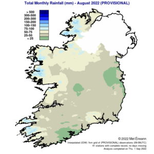
Total Monthly Rainfall (mm) for August 2022 (Provisional)
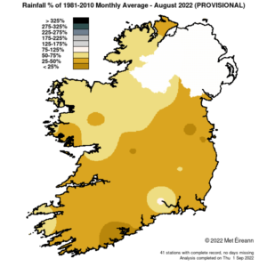
Rainfall % of 1981 – 2021 Monthly Average for August 2022 (Provisional)
Temperature: Above average everywhere, record high maximum daily temperatures for August reported at eleven stations
All mean air temperatures across the country were above their LTA for the month. Deviations from mean air temperature ranged from 0.2 °C (14.8 °C the month’s lowest mean temperature) at Malin Head, Co Donegal to 2.1 °C (17.1 °C the month’s highest mean temperature) at Cark Airport, Co Cork (its warmest August since 1995). Roches Point, Co Cork also reported the months highest mean temperature of 17.1 °C (1.7 °C above its LTA) (its warmest August on record (length 18 years)). The month’s highest temperature at a synoptic station was reported at Oak Park, Co Carlow on Friday 12th with a temperature of 31.7 °C (the highest August daily maximum temperature ever recorded at a synoptic station). This was surpassed the following day on Saturday 13th at the climate station in Durrow, Co Laois, where 32.1 °C was reported, which is now provisionally the highest ever August maximum temperature for Ireland. The month’s lowest air and grass minimum was recorded at Mount Dillon, Co Roscommon with the lowest air temperature reported on Monday 1st with 3.8 °C while the lowest grass minimum was -1.5 °C reported on Wednesday 17th. There was no air frost reported this month. The number of days with ground frost ranged from zero days at most stations to 3 days at Mount Dillon, Co Roscommon. Heatwaves were reported at seven stations between Tuesday 9th and Sunday 14th lasting between 5 and 6 days. These were at Shannon Airport, Co Clare, Cork Airport, Co Cork, Phoenix Park, Co Dublin, Dunsany, Co Meath (5 days), Oak Park, Co Carlow, Moore Park, Co Cork and Casement, Co Dublin (6 days). Eleven synoptic stations broke their August maximum temperature record. These were Oak Park, Co Carlow with 31.7 °C (length 18 years), Shannon Airport, Co Clare with 30.0 °C (length 76 years), Mount Dillon, Co Roscommon with 29.2 °C (length 7 years), Gurteen, Co Tipperary with 28.9 °C (length 14 years), Athenry, Co Galway with 28.5 °C (length 12 years), Newport, Co Mayo with 28.5 °C (length 62 years), Cork Airport, Co Cork with 28.3 °C ( length 60 years), Markree, Co Sligo with 28.3 °C (length 17 years), Mace Head, Co Galway with 27.4 °C (length 18 years) and Finner, Co Donegal with 26.5 °C (length 11 years). One station, Moore Park, Co Cork also broke its all-time maximum temperature record with 30.6°C (length 35 years).
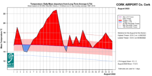
Cork Airport Temperature: Daily mean departure from LAT
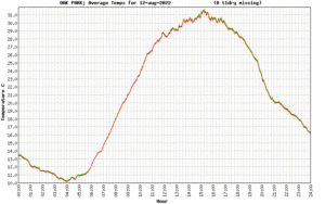
Oak Park, Co Carlow: Average temperatures for 12-Aug-2022
Sunshine: Sunny everywhere, highest in the South and East
All available sunshine totals were above their LTA. Percentage of monthly sunshine values ranged from 159% (monthly sunshine total of 240.0 hours) at Casement Aerodrome, Co Dublin to 172% (the month’s highest monthly sunshine total of 242.9 hours) at Shannon Airport, Co Clare. Monthly sunshine totals were lowest at Malin Head, Co Donegal with 172.1 hours (No LTA comparison*). The highest number of daily sunshine hours recorded this month was 14.6 hours at Malin Head, Co Donegal on Wednesday 10th. The number of dull days ranged from 1 day at both Casement Aerodrome, Co Dublin and Cork Airport to 5 days at Johnstown Castle, Co Wexford.
Wind: Not significantly strong
Monthly mean wind speeds ranged from 4.4 knots (8.1 km/h) at Moore Park, Co Cork to 11.3 knots (20.9 km/h) at Mace Head, Co Galway. There were no days with gales, strong gales or storms reported this month. Both the month’s highest gust and 10-minute mean wind speed was reported at Mace Head, Co Galway on Wednesday 3rd. The highest gust was 38 knots (70 km/h) while the month’s highest 10-minute mean wind speed was 30 knots (56 km/h).
The full report is available here
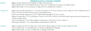
Extreme values at synoptic stations