Warm and sunny with record high April daily temperatures. Dry first half, wet second half
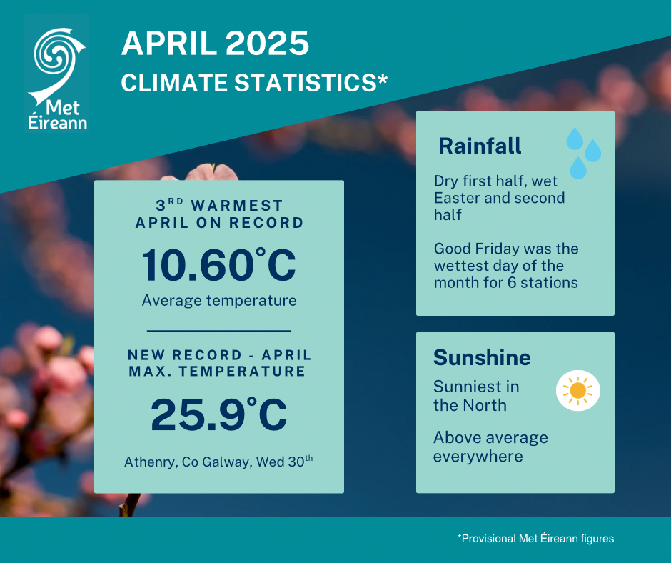
- The average national temperature for April 2025 (using the Island of Ireland dataset*) was 10.60 °C, which is 1.72 °C above the most recent 1991-2020 long-term average (LTA) and 2.50 °C above the 1961-1990 LTA.
- April 2025 was the 3rd warmest on record since 1900 and the warmest since 2011, which was the warmest April on record. April 2007 was as second warmest on record.
- The warmest April remains in 2011 (14 years ago) with an average temperature of 11.23°C and the coldest April remains in 1922 (103 years ago) with an average temperature of 5.45°C.
- Provisional gridded rainfall data suggests April 2025 averaged at 95.9 mm (118% of the 1991-2020 LTA or 122% of the 1981-2010 LTA).
- The wettest April was in 1966 (59 years ago) and the driest April was in 2017 (8 years ago).
April 2025 Climate Statistics
A month of contrasts. The first two weeks of April 2025 were dominated by high pressure over or to the north of Ireland. This kept it mostly dry in a predominantly easterly airflow, with plenty of sunshine. It became gradually warmer, especially in the Midlands and West. The settled spell broke down on Sunday 13th, as Atlantic weather fronts pushed across the country from the west, introducing a cooler westerly airflow with outbreaks of rain or showers.
This marked the beginning of a cooler and wetter couple of weeks where Atlantic low pressure dominated and brought numerous spells of heavy rain, especially to the Midlands, South and East. The first day with heavy rain came on Wednesday 16th as a wraparound occluded front, associated with low pressure that moved north from the Bay of Biscay towards Wales, stalled over the eastern half of the country. More widespread heavy rain came on Friday 18th and Saturday 19th as low pressure, which stalled to the south, pushed active weather fronts north over the country, with the heaviest rain over parts of the South. This was followed by further bands of rain or showers, sometimes heavy, up to Saturday 26th, when high pressure to the east began to take control once again.
The final four days of the month were dominated by high pressure to the east. This along with warm air advection from the south, which passed over sea surface temperatures that were much warmer than average for the time of year, led to record breaking maximum temperatures for April being reported on the final day of the month.
Rainfall: Dry first half, wet second half. Wettest in the Midlands, South and East
- Shannon Airport, Co Clare and Mount Dillon, Co Roscommon had their wettest April since 2009, while Phoenix Park, Co Dublin and Dunsany, Co Meath had their wettest April since 2012.
- Roches Point, Co Cork recorded 44.5 mm of rainfall on Friday 18th had its 2nd highest daily rainfall total for April on record (length 20 years) behind 49.8 mm, which fell on Monday 15th April 2019.
- Knock Airport, Co Mayo, Mount Dillon and Gurteen, Co Tipperary all had their wettest April day on record on Friday 18th (record lengths between 17 and 28 years).
- Shannon Airport, Co Clare had its wettest April day since 1978, Mullingar, Co Westmeath had its wettest April day since 1991 and Newport, Co Mayo had its wettest April day since 1999, all on Friday 18th.
- Casement, Co Dublin had its wettest April day since 2002 on Wednesday 16th.
- Six stations, mostly in the East, had dry spells* between March 28th and April 14th lasting between 15 and 18 days.
- One station, Casement Aerodrome, Co Dublin, had a partial drought* lasting 29 days ending on 12th April.
- Dunsany, Co Meath saw 14 consecutive dry days (0.0 mm) between Sunday 30 March and Saturday 12 April inclusive.
The majority of monthly rainfall totals were above their 1991-2020 Long-Term Average (LTA). Percentage of monthly rainfall values ranged from 83% (the month’s lowest rainfall total of 61.0 mm) at Sherkin Island, Co Cork to 172 % (the month’s highest rainfall total of 110.4 mm) at Roches Point, Co Cork. The month’s wettest day was also recorded at Roches Point, Co Cork with 44.5 mm on Friday 18th (its 2nd highest daily rainfall total for April on record (length 20 years) behind 49.8 mm, which fell on Monday 15th April 2019).
The number of rain days* ranged from 10 days at Shannon Airport, Co Clare to 17 days at Sherkin Island, Co Cork. The number of wet days* ranged from 8 days at Shannon Airport, Co Clare to 13 days at both Valentia Observatory, Co Kerry and Belmullet, Co Mayo. The number of very wet days* ranged from 2 days at Moore Park, Co Cork to 5 days at both Johnstown Castle, Co Wexford and Mount Dillon, Co Roscommon. Shannon Airport, Co Clare and Mount Dillon, Co Roscommon had their wettest April since 2009, while Phoenix Park, Co Dublin and Dunsany, Co Meath had their wettest April since 2012. Knock Airport, Co Mayo, Mount Dillon and Gurteen, Co Tipperary all had their wettest April day on record on Friday 18th (record lengths between 17 and 28 years). Shannon Airport, Co Clare had its wettest April day since 1978, Mullingar, Co Westmeath had its wettest April day since 1991 and Newport, Co Mayo had its wettest April day since 1999, all on Friday 18th, while Casement, Co Dublin had its wettest April day since 2002 on Wednesday 16th.
Six stations, mostly in the East, had dry spells* between March 28th and April 14th lasting between 15 and 18 days. One station, Casement Aerodrome, Co Dublin, had a partial drought* lasting 29 days ending on 12th April. Dunsany, Co Meath saw 14 consecutive dry days (0.0 mm) between Sunday 30 March and Saturday 12 April inclusive.
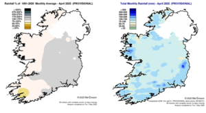
Rainfall % of 1991 – 2020 Monthly Average for April 2025 (Provisional) Total Monthly Rainfall (mm) for April 2025 (Provisional)
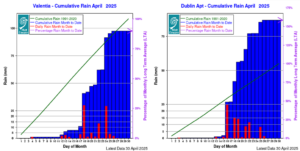
Valentia Obs., Co Kerry – Cumulative Rain April 2025 Dublin Airport, Co Dublin- Cumulative Rain April 2025
Temperature: Significantly above average, record high daily maximum temperatures reported at 17 stations
- Shannon Airport, Co Clare with a mean temperature of 11.9 °C (2.3 °C above its LTA) had its 2nd warmest April on record behind 2011, which had a mean monthly temperature of 12.0 °C (record length 79 years).
- Valentia Observatory, Co Kerry (11.6 °C), Belmullet, Co Mayo (11.3 °C) and Knock Airport, Co Mayo (10.2 °C) all had their joint warmest April on record, tying with 2011 (record lengths between 28 and 85 years).
- Mace Head, Co Galway (11.4 °C) had its warmest April on record (length 19 years).
- All other stations had their warmest April since 2011.
- Athenry, Co Galway recorded the highest April maximum temperature on record for Ireland on Wednesday 30th with a temperature of 25.9 °C.
- Along with Athenry, Co Galway, sixteen other stations reported their highest daily maximum temperature for April on record, all on Wednesday 30th and Dublin Airport tied its record (record lengths between 14 and 85 years).
All mean air temperatures across the country were above their LTA for the month. Deviations from mean air temperatures ranged from +1.4 °C (10.2 °C mean temperature) at Johnstown Castle, Co Wexford to +2.5 °C (10.2 °C mean temperature) at Knock Airport, Co Mayo. Mean temperatures for the month ranged from 9.6 °C at Dublin Airport, Co Dublin (1.5 °C above its LTA) to 11.9 °C at Shannon Airport, Co Clare (2.3 °C above its LTA) (its 2nd warmest April on record behind 2011, which had a mean monthly temperature of 12.0 °C (record length 79 years)).
The month’s highest temperature was reported at Athenry, Co Galway on Wednesday 30th with a temperature of 25.9 °C (the highest April daily maximum temperature on record for Ireland). The month’s lowest air minimum was recorded on Thursday 17th at Markree, Co Sligo with -2.4 °C while the lowest grass minimum was -7.3 °C reported at both Mount Dillon, Co Roscommon and Claremorris, Co Mayo on Thursday 17th.
More than half of stations reported ground frost. The number of days with ground frost ranged from zero days at Belmullet, Co Mayo to 18 days at both Phoenix Park, Co Dublin and Markree, Co Sligo. Less than half of stations reported air frost. The number of days with air frost ranged from zero days at a few stations to 6 days at Mount Dillon, Co Roscommon.
Valentia Observatory, Co Kerry (11.6 °C), Belmullet, Co Mayo (11.3 °C) and Knock Airport, Co Mayo (10.2 °C) all had their joint warmest April on record, tying with 2011 (record lengths between 28 and 85 years), while Mace Head, Co Galway (11.4 °C) had its warmest April on record (length 19 years). All other stations had their warmest April since 2011. Along with Athenry, Co Galway, sixteen other stations reported their highest daily maximum temperature for April on record, all on Wednesday 30th (record lengths between 14 and 85 years).
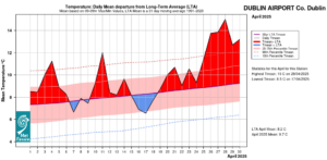
Dublin Airport, Co Dublin Temperature: Daily mean departure from LTA for April 2025 based on 09-09hr Max/Min values.
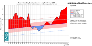
Shannon Airport, Co Clare Temperature: Daily mean departure from LTA for April 2025 based on 09-09hr Max/Min values.
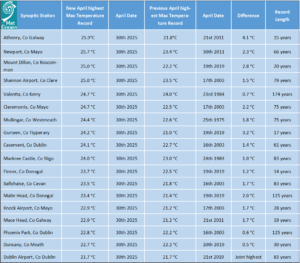
Table 1: April 2025 station air temperature records provisionally broken or tied on Wednesday 30 April 2025: Difference from previous station records shown. Athenry, Co Galway provisionally broke the national April maximum Air temperature record with 25.9°C. The previous record was 25.8°C set in 1984 in The Glenties, Co Donegal.
Sunshine: Above average everywhere, sunniest in the North
All available sunshine totals were above their LTA for the month. Percentage of monthly sunshine values ranged from 127% (monthly sunshine total of 204.0 hours) at Cork Airport to 131% (monthly sunshine total of 212.6 hours) at Shannon Airport, Co Clare. Monthly sunshine totals ranged from 199.8 hours (no LTA comparison*) at Johnstown Castle, Co Wexford to 237.9 hours (no LTA comparison*) at Malin Head, Co Donegal (its highest monthly sunshine total for April (length 68 years)). The highest number of daily sunshine hours recorded this month was 14.2 hours at Dublin Airport on the 30th (its highest daily sunshine for April on record (length 83 years)). The number of dull days* ranged from 3 days at Belmullet, Co Mayo to 6 days at Johnstown Castle, Co Wexford.
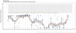
Hours of Bright Sunshine observed at nine stations for each day of the month of April 2025, grouped by province relative to the highest number of hours possible by end of month (shaded box).
Wind: Not significantly strong
Monthly mean wind speeds ranged from 5.5 knots (10.2 km/h) at Ballyhaise, Co Cavan to 12.7 knots (23.5 km/h) at Malin Head, Co Donegal. There were no days with gales, strong gales or storms reported this month. Both the month’s highest gust and 10-minute mean wind speeds were reported on Friday 18th. The highest gust was 43 knots (80 km/h) reported at Newport, Co Mayo while the month’s highest 10-minute mean wind speed was 33 knots (61 km/h) at Malin Head, Co Donegal.
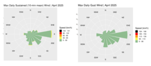
Wind roses for April 2025, sustained 10-min mean and gust.
PDF report and charts are available here.
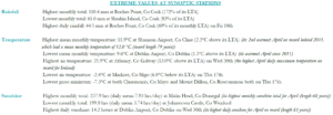
Extreme values for April 2025 at synoptic stations.
*Issued by Met Éireann on Friday 2nd May 2025. This report is based on available preliminary data from 25 principal weather stations operated by Met Éireann. Synoptic station data is midnight to midnight UTC. Long-Term Averages (LTAs) and “average” refer to the period 1991-2020 unless stated. A rain day is a day on which 0.2 mm or more of rainfall is measured. A wet day is a day with 1.0 mm or more of rainfall. A dull day is a day with less than 0.5 hours of sunshine. A very wet day is a day with 10.0 mm or more of rainfall. Climatological dry periods – An absolute drought is a period of 15 or more consecutive days to none of which is credited 0.2 mm or more of precipitation. A partial drought is a period of at least 29 consecutive days, the mean daily rainfall of which does not exceed 0.2 mm. A dry spell is a period of 15 or more consecutive days to none of which is credited 1.0 mm or more of precipitation (i.e. daily tot < 1.0 mm). A heatwave occurs where there are 5 consecutive days or more with maximum temperature over 25°C (that is, a daily maximum screen air temperature > 25° C). The ‘Island of Ireland’ dataset is 125 years long and runs between 1900 and 2023. For this dataset the long term averages from the 1961-1990 reference period are used for comparison as is standard for long-term climate change assessments. *Sunshine data is from the Autosol Network. LTAs for these sites are currently not used for comparison purposes. For more information, contact Met Éireann at 01-8064200 or e-mail: enq@met.ie