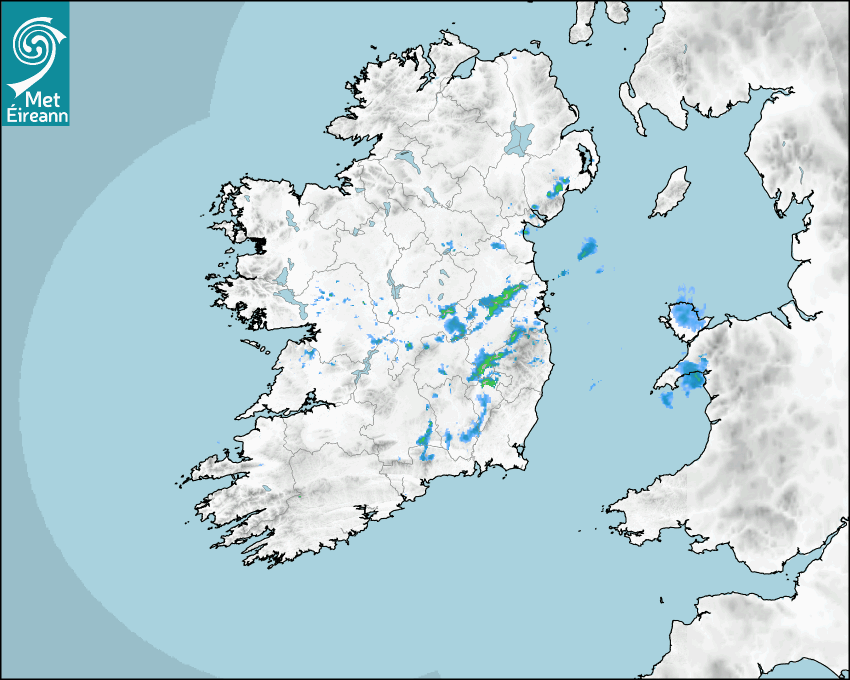

Latest Rainfall Radar showing live precipitation and the last 90 minutes precipitation over Ireland, updated every 5 minutes. Precipitation can be rain, hail or snow. Accumulations can refer to rainfall only.
Lightning strikes, when they occur, are displayed as a cross. Initially, they are red but change to orange and then yellow after a period, then disappear © Met Office ATDNet.
Ground Clutter may appear (South Co. Dublin), bright bands and spokes may also be present in images. They are artefacts (false echoes) of rainfall radar systems and should be ignored. Further information on Radar here
Met Éireann forecasters manually produce the weather icons for midday and midnight to reflect the predicted major weather type for these times.
The rainfall forecast is direct model output from Numerical Weather Prediction models but is a guideline only. Rain refers to precipitation, which can be rain, sleet or snow. It forecasts how much rain will fall (in mm) hourly during the previous hour (accumulations), then in 3 hourly and finally 6 hourly accumulations up to 7 days. This service is based on data and products of the HARMONIE-AROME and the European Centre for Medium-range Weather Forecasts (ECMWF) models.
The wind is direct model output from Numerical Weather Prediction models but is a guideline only. It forecasts the strength of the wind (in knots and km/h) at 10m for the top of each hour, in hourly, then 3 hourly and finally 6 hourly intervals up to 7 days. The wind arrow tip points in the direction the wind is blowing and the tail length indicates wind strength. However, in the text forecast below, it is described as where it is blowing from. This service is based on data and products of the HARMONIE-AROME and the European Centre for Medium-range Weather Forecasts (ECMWF) models.
The temperature is direct model output from Numerical Weather Prediction models but is a guideline only. It forecasts air temperature on land and over sea in °C for the top of each hour, 3 hourly and finally 6 hourly intervals up to 7 days. Minus zero (-0) indicates values between 0 to -0.5°C. This service is based on data and products of the HARMONIE-AROME and the European Centre for Medium-range Weather Forecasts (ECMWF) models.
The Mean Sea Level Pressure (MSLP) is direct model output from Numerical Weather Prediction models but is a guideline only. It forecasts the MSLP in hecto Pascals (hPa) for the top of that hour initially in 3 hourly intervals, then 6 hourly. This service is based on data and products of the HARMONIE-AROME and the European Centre for Medium-range Weather Forecasts (ECMWF) models.
National Forecast
17 June 2025 11:51
Today
Rather cloudy for a time today with patchy outbreaks of rain moving eastwards. However, sunny spells will develop from the west this afternoon with good sunshine to end the day. Highest temperatures of 17 to 21 degrees in no more than moderate southwesterly breezes.
Tonight
Dry tonight with clear spells. Towards morning, damp and drizzly conditions will arrive into the far northwest. Lowest temperatures of 6 to 11 degrees in just light variable breezes.
Tomorrow
Generally dry, calm, warm and sunny on Wednesday, however it will be a little cooler and cloudier across Ulster with some drizzle further north of the province. Top temperatures of 16 to 23 degrees.
Met News

05th June 2025
Climate Statement for Spring 2025
Ireland records highest average temperature and ho... more

04th June 2025
Climate Statement for May 2025
Warm, dry, calm and very sunny May for Ireland I... more

23rd May 2025
Marine Heatwave off Ireland’s Coast in May 2025
High pressure and easterly winds are contributing ... more
