Updated on Tuesday, 9th December 2025, valid until further notice
A deepening Atlantic low-pressure system, named Storm Bram by Met Éireann, will bring strong winds and heavy rain to Ireland on the night of Monday 8th December and during Tuesday 9th.
Met Éireann is closely monitoring a developing Atlantic system expected to bring strong winds, high coastal water levels, and periods of heavy rainfall to Ireland from late Monday night (8th December) through Tuesday (9th December).
After a week of persistent rain, soils across the country are already highly saturated and many rivers are approaching bank-full conditions, so any additional rainfall is likely to result in surface and river flooding on Tuesday and possibly during following days.
WHY HAS IT BEEN NAMED?
Met Éireann has been monitoring this system for a number of days now, and while it is a very unstable system, not yet developed at the time of naming it, it is clear that it will bring compound impacts to a number of counties during the daytime on Tuesday 9th December, due to the interaction of the strong winds with the rain and the coinciding high tides. The storm has been named due to the effect of those strong winds on coastal areas at times of high tide, and the heavy rain falling on already saturated ground, all of which increase flood risk.
Meteorologist Matthew Martin, says:
“It’s looking increasing likely that Ireland will experience some very inclement weather from Monday night and through Tuesday. A low-pressure system in the Atlantic is going to deepen fairly rapidly as it approaches the southwest coast on Monday night. Initially there will be a spell of heavy rain before a swathe of very strong winds develop. There remains some uncertainty in the track and intensity of the system, but it looks likely that this will be an impactful event in some areas, especially in coastal areas of the south, west and northwest. Given its evolving nature, we have issued a yellow wind warning for the entire country, followed by a set of orange wind warnings for southern and western coastal counties, as they are most vulnerable to the compound effects of the wind at high tide. We have also issued a yellow rainfall warning for Carlow, Kilkenny, Wexford, Cork, Kerry, Tipperary and Waterford, but we encourage everyone to check in regularly with Met Éireann’s forecasts and warnings, as the situation is likely to evolve with certainty in the system track and timings increases.”
Matthew continues:
“Flooding impacts are expected as the rain will fall on already saturated ground and many rivers are currently approaching bank full conditions. We are in a period of high astronomical tides, which will coincide with the strong, potentially onshore winds, so there is high risk of coastal flooding. We echo the well-known advice of the Irish Coast Guard: “Stay Back, Stay High, Stay Dry”.
The high tides will prevent the rivers from discharging to the sea, significantly increasing the risk of upstream flooding along low-lying areas. People should refer to the guidance of their local authorities and emergency responders in their area.”
METEOROLOGICAL SITUATION
A deepening Atlantic depression is forecast to track close to Ireland on Monday night and Tuesday.
Southerly winds ahead of the system will strengthen on Monday night, with periods of severe wind gusts possible, especially near exposed Atlantic coasts. The strong winds will continue through Tuesday, veering southwest to west in direction during the day. Heavy rainfall late Monday into Tuesday morning will fall over ground that is already water-logged, increasing runoff and river response times.
Confidence remains moderate regarding the exact track and intensity of the system; small shifts will influence the severity of impacts. A slight shift in the system’s path could influence peak wind gusts, timing of strongest winds, and the extent of coastal impacts. Met Éireann will continue to monitor the system closely and update warnings as required.
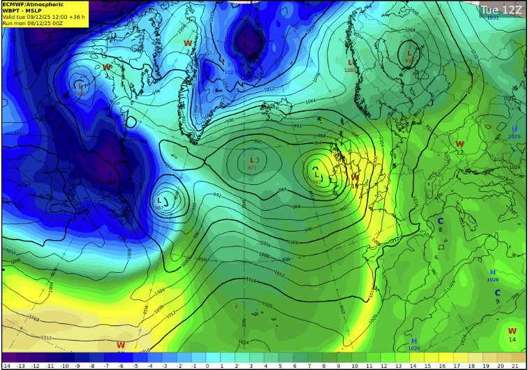
Fig. 1: The current ECMWF model prediction of the position of the low-pressure system at midday on Tuesday (9 December), at the time of publication on Monday 8th December, subject to changes.
WARNINGS AND IMPACTS: The intensity of the winds and their impacts will depend on the interaction of the low with the jet stream, but as a mean for awareness of the potential impacts, Met Éireann has issued the following warnings (on 7th December at time of publication):
A Status Yellow rain warning across southern counties, with heavy rain expected to fall on already saturated ground and with many rivers in southern regions approaching bank full conditions after a week of steady rain.
Expected impacts, throughout Tuesday (even if the rain warning will expire on Tuesday morning) are:
- Surface and river flooding, through the whole day Tuesday and possibly Wednesday, even if the rain warning will expire on Tuesday morning, as the rivers may take time to respond. Coinciding high tides will prevent river water from discharging to the sea, causing water to back up and significantly increasing the risk of upstream flooding along low-lying areas, especially across rivers in Cork, south Kerry, south Tipperary and Waterford.
- Difficult travel conditions
- Potential disruption to outdoor events.
A Status Yellow wind warning for Ireland all day Tuesday, followed by Orange wind warning for southern and western counties which have been extended to all counties in Ireland for different times across Tuesday, due to very strong to gale force southerly winds expected, strongest along the coast.
Expected impacts include:
- Very difficult travel conditions: Surface water, reduced visibility, and strong winds may make driving hazardous and could lead to delays on roads, rail, ferry and/or air services. Allow extra time and take caution on exposed routes.
- Flooding in low-lying coastal areas: The combination of the southerly, onshore winds with very high astronomical tides and wave action will heighten the risk of coastal flooding. Surge levels will rise to 0.8m in some locations and significant waves are forecast. Coastal flooding is likely, particularly during high tide times and in exposed low-lying areas. High tide on southern and western coasts is early Tuesday morning (7-9am), whilst time of high tide is close to 2pm on eastern coasts. “Stay Back, Stay High, Stay Dry”.
- Wave overtopping: Large waves may breach sea walls or coastal barriers, posing risks to people near shorelines and potentially impacting coastal infrastructure in exposed locations.
- Fallen trees, debris and loose objects displaced: Strong winds could lift unsecured items, increasing the risk of damage or hazards on roads and in public spaces.
- Outdoor events impacted: Weather conditions may lead to delays, cancellations, or the need for additional safety measures for outdoor activities.
The warnings may be updated as new model runs are analysed and certainty increases. For the latest warnings details, please check Warnings & Advisories – Met Éireann – The Irish Meteorological Service
HOW TO STAY SAFE IN SEVERE WEATHER – BE WINTER READY
Stay informed & plan ahead:
- Stay up-to date with the forecast and the warnings for your county on met.ie, the Met Éireann app or Met Éireann socials (@meteireann).
- Check in with your local authority and emergency management stakeholders (Irish Coast Guards, Gardaí, etc) via their websites and social channels on road closures, flooding updates, and community alerts.
- Allow for disruption during Tuesday morning commute.
- Plan extra travel time and reduce speed.
- Expect surface water, debris and poor visibility on Tuesday morning.
- Check in with neighbours, older people or anyone who may need assistance in case conditions worsen.
This is a multi-hazard event – be aware of elevated flood risk and high winds:
- Coastal areas are likely to experience wave overtopping, storm surge, and tidal flooding, especially in low-lying locations.
- Keep away from coastal edges, harbours, piers and low-lying promenades during high tide. The Irish Coast Guard advice remains: “Stay Back, Stay High, Stay Dry.”
- Stay back from riverbanks, streams and canals – water levels may rise quickly.
- Keep children and pets away from waterways and flooded areas.
- Don’t try to walk, cycle or drive through flooded areas – turn back and use another route.
- Remember: As little as 150mm of fast-flowing water can knock you off your feet and 300mm of fast-flowing water can move most cars off the road.
- Ensure your mobile is phone is fully charged to enable communication in advance of the event and keep local emergency numbers in your phone.
- Take care on exposed roads and bridges.
- Watch for fallen branches and debris.
- Allow extra time for your trip and if you are driving a high sided vehicle, try to anticipate exposed sections of roadway where winds will be stronger.
- Secure loose outdoor items ahead of strengthening winds.
- ESB Networks is highlighting the dangers posed by fallen live wires and is advising the public and the emergency services to stay away from these fallen cables and to report such cases to it immediately. ESB Emergency Services can be contacted at 1800 372 999.
- Keep a small amount of food, medical and water supplies in case it’s dangerous to step out of the home.
- Uisce Éireann customers can check the website and social media channels for updates and to get in touch with any issues or concerns via their 24/7 customer care centre at 1800 278 278. The public can also sign up online to their free text alert system to get regular updates about their local supplies – see www.water.ie.”
- “Be Winter Ready”: Follow recommendations before, during and after the event on gov.ie – Be Winter Ready (www.gov.ie)
NOTE THAT: The warnings are likely to be updated. Please keep in touch with Met Éireann’s social media channels, www.met.ie and the Met Éireann app to stay up to date with the forecast and any warnings’ updates.
The timing and location of extreme weather occurrences can significantly affect their impact. It’s important to note that in any individual weather event, not every location within a warning area may experience the same degree of weather or impacts.
When severe weather is expected, weather and impacts at lower levels are also likely to be experienced. The type and level of impacts can be strongly affected by previous weather conditions. When issuing a warning, Met Éireann takes into consideration the forecasted conditions and thresholds, as well as previous weather conditions that may increase the level of impact expected for particular areas.
WHY AND HOW ARE STORMS NAMED?
Storms are named when they could cause ‘medium’ or ‘high’ impacts in one of the three partner countries. This enables consistent, authoritative messaging to the public and other stakeholders to help them to prepare for and stay safe during potentially severe weather events.
Since 2015, Met Éireann and the UK Met Office have been working together on the naming programme and were joined by the Netherlands’ KNMI in 2019, to form the ‘western group’ of European weather services.
When a storm is forecast, the national weather service that expects the biggest impact from the severe weather to hit its region, or is likely to be first affected by it, names the storm. Storm naming happens in conjunction with orange/red weather warnings, which could be for wind, rain or snow, or a combination of these conditions. Those warnings are, in turn, issued based on a combination of numerical thresholds and the potential impacts foreseen.
HOW ARE STORM NAMES CHOSEN?
Met Éireann, the UK Met Office and KNMI publish a new list of storm names for each Storm Season, which commences on 1st September.
This 2025/26 season, each of the three meteorological services contributed seven names to the season’s list. Met Éireann called on Ireland’s public to submit their preferred names through a social media campaign. More than 10,000 names were received from 4,137 members of the public.
The full 2025/26 list is Amy, Bram, Chandra, Dave, Eddie, Fionnuala, Gerard, Hannah, Isla, Janna, Kasia, Lilith, Marty, Nico, Oscar, Patrick, Ruby, Stevie, Tadhg, Violet, Wubbo.
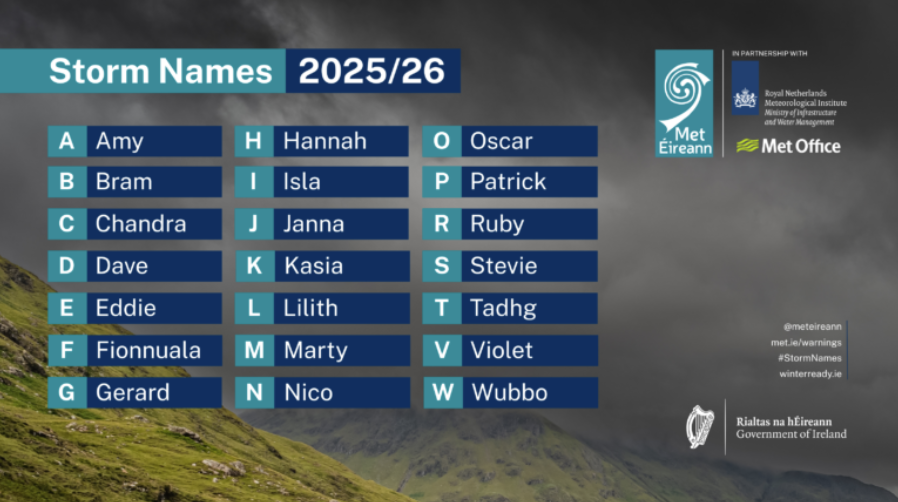
Figure 2– Storm Names 2025/26 list (The names chosen by Met Éireann are in bold. Letters Q, U, X, Y, Z are not included, which is in line with the US National Hurricane Center naming convention).
DECEMBER STORMS IN IRELAND:
It is very common for Ireland to see named storms in winter and in particular in December. Only last year at this time Ireland was impacted by Storm Darragh, and every year but one, since the naming initiative started we have seen named storms in the month of December.
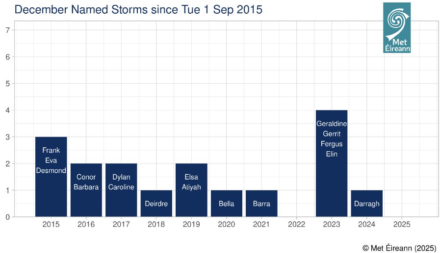
Fig 3 – 17 December named Storms have affected Ireland since Tuesday 1st September 2015 and prior to Storm Bram.
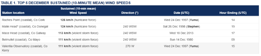
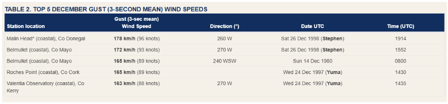
The top 5 highest sustained wind speeds observed in December for Ireland are:
The top 5 highest gust wind speeds observed in December for Ireland are:
PAST STORM SEASONS OVERVIEW
- In the past season (2024/25), there were six named storms affecting the area, starting with Ashley (October 2024), Bert, Conall, Darragh, Éowyn and closing with Floris (August 2025). All of these storms were named by the Western Europe Group of National Meteorological Services, formed by the UK Met Office, KNMI and Met Éireann.
- The highest number of named storms in a season, affecting Ireland, is fourteen (14), in 2023/24. Two of these storms (Elisa and Geraldine) were named by the Southwestern Europe Group (France, Portugal and Spain). The lowest number of named storms, affecting Ireland, since the initiative began, was four, in 2022/23.
- On average, there have been around eight named storms each season since the storm naming initiative began in 2015.
- 2015/16 remains the season with the greatest number of storms reaching storm force 10, when nine of the 11 named storms observed storm force 10 or higher sustained wind speeds at coastal stations.
- Last season 2024/25, four (of the six) named storms observed storm force 10 or higher sustained wind speeds on land in Ireland:
- Ashley on Sunday 20th October 2024, with gusts up to 137 km/h (Storm Force).
- Bert on Saturday 23rd November 2024, with gusts up 115 km/h (Storm Force).
- Darragh on Friday 6th December 2024, with gusts up to 141 km/h (Violent Storm Force).
- Éowyn on Friday 24th January 2025, with gusts up to 184 km/h (Hurricane Force).
- Prior to Storm Éowyn, the last hurricane force winds observed on land for Ireland were during Storm Darwin on Wednesday, 12th February 2014, when gusts reached up to 159 km/h.
- During Storm Éowyn, a gust of 184km/h was recorded at Mace Head Co. Galway on 24th January 2025. This is provisionally the strongest gust speed ever recorded in Ireland, breaking the previous record of 182km/h set at Foynes, Co. Limerick in 1945.
For more information on storm names and past storms, see Storm Centre and Major Weather Events.
Issued on 7th December 2025, valid until further notice
A deepening Atlantic low-pressure system will impact Ireland on the night of Monday 8th December and during Tuesday 9th.
Met Éireann is closely monitoring a developing Atlantic system with the potential to bring very strong winds, high coastal water levels, and periods of heavy rainfall to Ireland from late Monday night (8th December) through Tuesday (9th December).
After a week of persistent rain, soils across the country are already highly saturated and many rivers are approaching bank-full conditions, so any additional rainfall is likely to result in surface and river flooding on Tuesday and possibly during following days.
Meteorologist Matthew Martin, says:
“It’s looking increasing likely that Ireland will experience some very inclement weather from Monday night and through Tuesday. A low-pressure system in the Atlantic is going to deepen fairly rapidly as it approaches the country on Monday night. Initially there will be a spell of heavy rain before a swathe of very strong winds develop. There remains a good deal of uncertainty in the track and intensity of the system, but it has the potential to be an impactful event. Given its evolving nature, we have issued a yellow wind warning for the entire country which will be updated when certainty increases, as well as yellow rainfall warnings for certain areas, and we encourage everyone to check in regularly with Met Éireann’s forecasts and warnings.
Flooding impacts are expected as the rain will fall on already saturated ground and many rivers are currently approaching bank full conditions. We are in a period of high astronomical tides, which will coincide with the strong, potentially onshore winds, so coastal flooding is likely. We echo the well-known advice of the Irish Coast Guard: “Stay Back, Stay High, Stay Dry”.
The high tides will prevent the rivers from discharging to the sea, significantly increasing the risk of upstream flooding along low-lying areas. People should refer to the guidance of their local authorities and emergency responders in their area.”
METEOROLOGICAL SITUATION
A deepening Atlantic depression is forecast to track close to Ireland on Monday night and Tuesday.
Southerly winds ahead of the system will strengthen on Monday night, with periods of severe wind gusts possible, especially near exposed Atlantic coasts. The strong winds will continue through Tuesday, veering southwest to west in direction during the day. Heavy rainfall late Monday into Tuesday morning will fall over ground that is already water-logged, increasing runoff and river response times.
The system hasn’t developed yet (as of Sunday afternoon). Confidence remains moderate regarding the exact track and intensity of the system; small shifts will influence the severity of impacts. A slight shift in the system’s path could influence peak wind gusts, timing of strongest winds, and the extent of coastal impacts. Met Éireann will continue to monitor the system closely and update warnings as required.
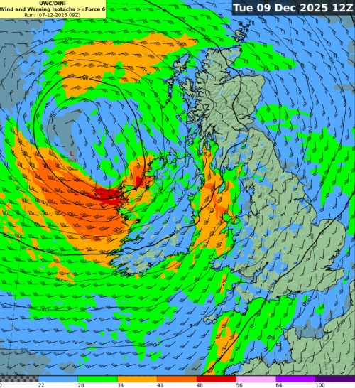
Fig. 1: A current model prediction of the position of the low-pressure system at midday on Tuesday (9 December) and the forecast mean wind speed in knots
WARNINGS AND IMPACTS:
The intensity of the winds and their impacts will depend on the interaction of the low with the jet stream, but as a mean for awareness of the potential impacts, Met Éireann has issued the following warnings (on 7th December at time of publication):
A Status Yellow rain warning across southern counties, with heavy rain expected to fall on already saturated ground and with many rivers in southern regions approaching bank full conditions after a week of steady rain.
Expected impacts, throughout Tuesday (even if the rain warning will expire on Tuesday morning) are:
• Surface and river flooding, through the whole day Tuesday, even if the rain warning will expire on Tuesday morning, as the rivers may take time to respond. Coinciding high tides will prevent river water from discharging to the sea, causing water to back up and significantly increasing the risk of upstream flooding along low-lying areas, especially across rivers in Cork, south Kerry, south Tipperary and Waterford.
• Difficult travel conditions
• Potential disruption to outdoor events.
A Status Yellow wind warning for Ireland all day Tuesday, due to very strong and gusty southerly winds expected, and the possibility of gales near coastal areas.
Expected impacts include:
• Difficult travel conditions: Surface water, reduced visibility, and strong winds may make driving hazardous and could lead to delays on roads, rail, and ferry services. Allow extra time and take caution on exposed routes.
• Flooding in low-lying coastal areas: The combination of the southerly, onshore winds with very high astronomical tides and wave action will heighten the risk of coastal flooding. Surge levels will rise to 0.8m in some locations and significant waves are forecast. Coastal flooding is likely, particularly during high tide times and in exposed low-lying areas. High tide on western and southern coasts is early Tuesday morning (7-9am), whilst time of high tide is close to 2pm on eastern coasts. “Stay Back, Stay High, Stay Dry”.
• Wave overtopping: Large waves may breach sea walls or coastal barriers, posing risks to people near shorelines and potentially impacting coastal infrastructure in exposed locations.
• Debris and loose objects displaced: Strong winds could lift unsecured items, increasing the risk of minor damage or hazards on roads and in public spaces.
• Outdoor events impacted: Weather conditions may lead to delays, cancellations, or the need for additional safety measures for outdoor activities.
The warnings may be updated as new model runs are analysed and certainty increases. For all warnings details, please check Warnings & Advisories – Met Éireann – The Irish Meteorological Service
HOW TO STAY SAFE IN SEVERE WEATHER – BE WINTER READY
Stay informed & plan ahead:
Stay up-to date with the forecast and the warnings for your county on met.ie, the Met Éireann app or Met Éireann socials (@meteireann).
- Check in with your local authority and emergency management stakeholders (Irish Coast Guards, Gardaí, etc) via their websites and social channels on road closures, flooding updates, and community alerts.
- Allow for disruption during Tuesday morning commute.
- Plan extra travel time and reduce speed.
- Expect surface water, debris and poor visibility on Tuesday morning.
- Check in with neighbours, older people or anyone who may need assistance in case conditions worsen.
Be aware of elevated flood risk and high winds:
- Ensure your mobile is phone is fully charged to enable communication in advance of the event and keep local emergency numbers in your phone.
- Take care on exposed roads and bridges.
- Watch for fallen branches and debris.
- Allow extra time for your trip and if you are driving a high sided vehicle, try to anticipate exposed sections of roadway where winds will be stronger.
- Secure loose outdoor items ahead of strengthening winds.
- ESB Networks is highlighting the dangers posed by fallen live wires and is advising the public and the emergency services to stay away from these fallen cables and to report such cases to it immediately. ESB Emergency Services can be contacted at 1800 372 999.
- Stay back from riverbanks, streams and canals – water levels may rise quickly.
- Keep children and pets away from waterways and flooded areas.
- Don’t try to walk, cycle or drive through flooded areas – turn back and use another route.
- Remember: As little as 150mm of fast-flowing water can knock you off your feet and 300mm of fast-flowing water can move most cars off the road.
- Coastal areas may experience wave overtopping, storm surge, and tidal flooding, especially in low-lying locations.
- Keep away from coastal edges, harbours, piers and low-lying promenades during high tide. The Irish Coast Guard advice remains: “Stay Back, Stay High, Stay Dry.”
- Keep a small amount of food, medical and water supplies in case it’s dangerous to step out of the home.
- “Be Winter Ready”: Follow recommendations before, during and after the event on gov.ie – Be Winter Ready (www.gov.ie)
NOTE THAT: The warnings are likely to be updated. Please keep in touch with Met Éireann’s social media channels, www.met.ie and the Met Éireann app to stay up to date with the forecast and any warnings’ updates.
The timing and location of extreme weather occurrences can significantly affect their impact. It’s important to note that in any individual weather event, not every location within a warning area may experience the same degree of weather or impacts.
When severe weather is expected, weather and impacts at lower levels are also likely to be experienced. The type and level of impacts can be strongly affected by previous weather conditions. When issuing a warning, Met Éireann takes into consideration the forecasted conditions and thresholds, as well as previous weather conditions that may increase the level of impact expected for particular areas.
Storm Bram bringing very strong winds and heavy rain
Updated on Tuesday, 9th December 2025, valid until further notice
A deepening Atlantic low-pressure system, named Storm Bram by Met Éireann, will bring strong winds and heavy rain to Ireland on the night of Monday 8th December and during Tuesday 9th.
Met Éireann is closely monitoring a developing Atlantic system expected to bring strong winds, high coastal water levels, and periods of heavy rainfall to Ireland from late Monday night (8th December) through Tuesday (9th December).
After a week of persistent rain, soils across the country are already highly saturated and many rivers are approaching bank-full conditions, so any additional rainfall is likely to result in surface and river flooding on Tuesday and possibly during following days.
WHY HAS IT BEEN NAMED?
Met Éireann has been monitoring this system for a number of days now, and while it is a very unstable system, not yet developed at the time of naming it, it is clear that it will bring compound impacts to a number of counties during the daytime on Tuesday 9th December, due to the interaction of the strong winds with the rain and the coinciding high tides. The storm has been named due to the effect of those strong winds on coastal areas at times of high tide, and the heavy rain falling on already saturated ground, all of which increase flood risk.
Meteorologist Matthew Martin, says:
“It’s looking increasing likely that Ireland will experience some very inclement weather from Monday night and through Tuesday. A low-pressure system in the Atlantic is going to deepen fairly rapidly as it approaches the southwest coast on Monday night. Initially there will be a spell of heavy rain before a swathe of very strong winds develop. There remains some uncertainty in the track and intensity of the system, but it looks likely that this will be an impactful event in some areas, especially in coastal areas of the south, west and northwest. Given its evolving nature, we have issued a yellow wind warning for the entire country, followed by a set of orange wind warnings for southern and western coastal counties, as they are most vulnerable to the compound effects of the wind at high tide. We have also issued a yellow rainfall warning for Carlow, Kilkenny, Wexford, Cork, Kerry, Tipperary and Waterford, but we encourage everyone to check in regularly with Met Éireann’s forecasts and warnings, as the situation is likely to evolve with certainty in the system track and timings increases.”
Matthew continues:
“Flooding impacts are expected as the rain will fall on already saturated ground and many rivers are currently approaching bank full conditions. We are in a period of high astronomical tides, which will coincide with the strong, potentially onshore winds, so there is high risk of coastal flooding. We echo the well-known advice of the Irish Coast Guard: “Stay Back, Stay High, Stay Dry”.
The high tides will prevent the rivers from discharging to the sea, significantly increasing the risk of upstream flooding along low-lying areas. People should refer to the guidance of their local authorities and emergency responders in their area.”
METEOROLOGICAL SITUATION
A deepening Atlantic depression is forecast to track close to Ireland on Monday night and Tuesday.
Southerly winds ahead of the system will strengthen on Monday night, with periods of severe wind gusts possible, especially near exposed Atlantic coasts. The strong winds will continue through Tuesday, veering southwest to west in direction during the day. Heavy rainfall late Monday into Tuesday morning will fall over ground that is already water-logged, increasing runoff and river response times.
Confidence remains moderate regarding the exact track and intensity of the system; small shifts will influence the severity of impacts. A slight shift in the system’s path could influence peak wind gusts, timing of strongest winds, and the extent of coastal impacts. Met Éireann will continue to monitor the system closely and update warnings as required.
Fig. 1: The current ECMWF model prediction of the position of the low-pressure system at midday on Tuesday (9 December), at the time of publication on Monday 8th December, subject to changes.
WARNINGS AND IMPACTS: The intensity of the winds and their impacts will depend on the interaction of the low with the jet stream, but as a mean for awareness of the potential impacts, Met Éireann has issued the following warnings (on 7th December at time of publication):
A Status Yellow rain warning across southern counties, with heavy rain expected to fall on already saturated ground and with many rivers in southern regions approaching bank full conditions after a week of steady rain.
Expected impacts, throughout Tuesday (even if the rain warning will expire on Tuesday morning) are:
A Status Yellow wind warning for Ireland all day Tuesday, followed by Orange wind warning for southern and western counties which have been extended to all counties in Ireland for different times across Tuesday, due to very strong to gale force southerly winds expected, strongest along the coast.
Expected impacts include:
The warnings may be updated as new model runs are analysed and certainty increases. For the latest warnings details, please check Warnings & Advisories – Met Éireann – The Irish Meteorological Service
HOW TO STAY SAFE IN SEVERE WEATHER – BE WINTER READY
Stay informed & plan ahead:
This is a multi-hazard event – be aware of elevated flood risk and high winds:
NOTE THAT: The warnings are likely to be updated. Please keep in touch with Met Éireann’s social media channels, www.met.ie and the Met Éireann app to stay up to date with the forecast and any warnings’ updates.
The timing and location of extreme weather occurrences can significantly affect their impact. It’s important to note that in any individual weather event, not every location within a warning area may experience the same degree of weather or impacts.
When severe weather is expected, weather and impacts at lower levels are also likely to be experienced. The type and level of impacts can be strongly affected by previous weather conditions. When issuing a warning, Met Éireann takes into consideration the forecasted conditions and thresholds, as well as previous weather conditions that may increase the level of impact expected for particular areas.
WHY AND HOW ARE STORMS NAMED?
Storms are named when they could cause ‘medium’ or ‘high’ impacts in one of the three partner countries. This enables consistent, authoritative messaging to the public and other stakeholders to help them to prepare for and stay safe during potentially severe weather events.
Since 2015, Met Éireann and the UK Met Office have been working together on the naming programme and were joined by the Netherlands’ KNMI in 2019, to form the ‘western group’ of European weather services.
When a storm is forecast, the national weather service that expects the biggest impact from the severe weather to hit its region, or is likely to be first affected by it, names the storm. Storm naming happens in conjunction with orange/red weather warnings, which could be for wind, rain or snow, or a combination of these conditions. Those warnings are, in turn, issued based on a combination of numerical thresholds and the potential impacts foreseen.
HOW ARE STORM NAMES CHOSEN?
Met Éireann, the UK Met Office and KNMI publish a new list of storm names for each Storm Season, which commences on 1st September.
This 2025/26 season, each of the three meteorological services contributed seven names to the season’s list. Met Éireann called on Ireland’s public to submit their preferred names through a social media campaign. More than 10,000 names were received from 4,137 members of the public.
The full 2025/26 list is Amy, Bram, Chandra, Dave, Eddie, Fionnuala, Gerard, Hannah, Isla, Janna, Kasia, Lilith, Marty, Nico, Oscar, Patrick, Ruby, Stevie, Tadhg, Violet, Wubbo.
Figure 2– Storm Names 2025/26 list (The names chosen by Met Éireann are in bold. Letters Q, U, X, Y, Z are not included, which is in line with the US National Hurricane Center naming convention).
DECEMBER STORMS IN IRELAND:
It is very common for Ireland to see named storms in winter and in particular in December. Only last year at this time Ireland was impacted by Storm Darragh, and every year but one, since the naming initiative started we have seen named storms in the month of December.
Fig 3 – 17 December named Storms have affected Ireland since Tuesday 1st September 2015 and prior to Storm Bram.
The top 5 highest sustained wind speeds observed in December for Ireland are:
The top 5 highest gust wind speeds observed in December for Ireland are:
PAST STORM SEASONS OVERVIEW
For more information on storm names and past storms, see Storm Centre and Major Weather Events.
Issued on 7th December 2025, valid until further notice
A deepening Atlantic low-pressure system will impact Ireland on the night of Monday 8th December and during Tuesday 9th.
Met Éireann is closely monitoring a developing Atlantic system with the potential to bring very strong winds, high coastal water levels, and periods of heavy rainfall to Ireland from late Monday night (8th December) through Tuesday (9th December).
After a week of persistent rain, soils across the country are already highly saturated and many rivers are approaching bank-full conditions, so any additional rainfall is likely to result in surface and river flooding on Tuesday and possibly during following days.
Meteorologist Matthew Martin, says:
“It’s looking increasing likely that Ireland will experience some very inclement weather from Monday night and through Tuesday. A low-pressure system in the Atlantic is going to deepen fairly rapidly as it approaches the country on Monday night. Initially there will be a spell of heavy rain before a swathe of very strong winds develop. There remains a good deal of uncertainty in the track and intensity of the system, but it has the potential to be an impactful event. Given its evolving nature, we have issued a yellow wind warning for the entire country which will be updated when certainty increases, as well as yellow rainfall warnings for certain areas, and we encourage everyone to check in regularly with Met Éireann’s forecasts and warnings.
Flooding impacts are expected as the rain will fall on already saturated ground and many rivers are currently approaching bank full conditions. We are in a period of high astronomical tides, which will coincide with the strong, potentially onshore winds, so coastal flooding is likely. We echo the well-known advice of the Irish Coast Guard: “Stay Back, Stay High, Stay Dry”.
The high tides will prevent the rivers from discharging to the sea, significantly increasing the risk of upstream flooding along low-lying areas. People should refer to the guidance of their local authorities and emergency responders in their area.”
METEOROLOGICAL SITUATION
A deepening Atlantic depression is forecast to track close to Ireland on Monday night and Tuesday.
Southerly winds ahead of the system will strengthen on Monday night, with periods of severe wind gusts possible, especially near exposed Atlantic coasts. The strong winds will continue through Tuesday, veering southwest to west in direction during the day. Heavy rainfall late Monday into Tuesday morning will fall over ground that is already water-logged, increasing runoff and river response times.
The system hasn’t developed yet (as of Sunday afternoon). Confidence remains moderate regarding the exact track and intensity of the system; small shifts will influence the severity of impacts. A slight shift in the system’s path could influence peak wind gusts, timing of strongest winds, and the extent of coastal impacts. Met Éireann will continue to monitor the system closely and update warnings as required.
Fig. 1: A current model prediction of the position of the low-pressure system at midday on Tuesday (9 December) and the forecast mean wind speed in knots
WARNINGS AND IMPACTS:
The intensity of the winds and their impacts will depend on the interaction of the low with the jet stream, but as a mean for awareness of the potential impacts, Met Éireann has issued the following warnings (on 7th December at time of publication):
A Status Yellow rain warning across southern counties, with heavy rain expected to fall on already saturated ground and with many rivers in southern regions approaching bank full conditions after a week of steady rain.
Expected impacts, throughout Tuesday (even if the rain warning will expire on Tuesday morning) are:
• Surface and river flooding, through the whole day Tuesday, even if the rain warning will expire on Tuesday morning, as the rivers may take time to respond. Coinciding high tides will prevent river water from discharging to the sea, causing water to back up and significantly increasing the risk of upstream flooding along low-lying areas, especially across rivers in Cork, south Kerry, south Tipperary and Waterford.
• Difficult travel conditions
• Potential disruption to outdoor events.
A Status Yellow wind warning for Ireland all day Tuesday, due to very strong and gusty southerly winds expected, and the possibility of gales near coastal areas.
Expected impacts include:
• Difficult travel conditions: Surface water, reduced visibility, and strong winds may make driving hazardous and could lead to delays on roads, rail, and ferry services. Allow extra time and take caution on exposed routes.
• Flooding in low-lying coastal areas: The combination of the southerly, onshore winds with very high astronomical tides and wave action will heighten the risk of coastal flooding. Surge levels will rise to 0.8m in some locations and significant waves are forecast. Coastal flooding is likely, particularly during high tide times and in exposed low-lying areas. High tide on western and southern coasts is early Tuesday morning (7-9am), whilst time of high tide is close to 2pm on eastern coasts. “Stay Back, Stay High, Stay Dry”.
• Wave overtopping: Large waves may breach sea walls or coastal barriers, posing risks to people near shorelines and potentially impacting coastal infrastructure in exposed locations.
• Debris and loose objects displaced: Strong winds could lift unsecured items, increasing the risk of minor damage or hazards on roads and in public spaces.
• Outdoor events impacted: Weather conditions may lead to delays, cancellations, or the need for additional safety measures for outdoor activities.
The warnings may be updated as new model runs are analysed and certainty increases. For all warnings details, please check Warnings & Advisories – Met Éireann – The Irish Meteorological Service
HOW TO STAY SAFE IN SEVERE WEATHER – BE WINTER READY
Stay informed & plan ahead:
Stay up-to date with the forecast and the warnings for your county on met.ie, the Met Éireann app or Met Éireann socials (@meteireann).
Be aware of elevated flood risk and high winds:
NOTE THAT: The warnings are likely to be updated. Please keep in touch with Met Éireann’s social media channels, www.met.ie and the Met Éireann app to stay up to date with the forecast and any warnings’ updates.
The timing and location of extreme weather occurrences can significantly affect their impact. It’s important to note that in any individual weather event, not every location within a warning area may experience the same degree of weather or impacts.
When severe weather is expected, weather and impacts at lower levels are also likely to be experienced. The type and level of impacts can be strongly affected by previous weather conditions. When issuing a warning, Met Éireann takes into consideration the forecasted conditions and thresholds, as well as previous weather conditions that may increase the level of impact expected for particular areas.
About Us