Recent Septembers in Ireland:
- 2016: The majority of stations reported above Long-Term Average (LTA) for rainfall and below average for sunshine, while all stations were average or above average for temperature.
- 2017: Cool & wet, with storm ‘Aileen’ tracking eastwards across Ireland mid-month. LTA rainfall values were above at most stations. Air temperatures were average or below average while over half of the sunshine totals were average or above average.
- 2018: Dry & Cool with two named storms, Ali & Bronagh. Rainfall totals were below average nearly everywhere. Mean temperatures were below average and sunshine totals were variable.
- 2019: Mild, wet, and sunny. Above average rainfall totals and mean temperatures for most, while sunshine totals were above average everywhere.
- 2020: Mostly warm, cool final third. Wet in the Northwest, dry in the South. Rainfall totals were mostly below average, with the majority of air temperatures near or above average, while sunshine totals were above average everywhere.
- 2021: Warm, dry & dull. Most monthly rainfall totals were below average, while all mean temperatures were above. Sunshine values were below average.
September 2022
Mostly mild. Wet in the Midlands, South and East
September was relatively mild and wet overall. After a dry start, a cut off upper level trough of low pressure, which moved down from the north, stalled just to the southwest of Ireland. The associated slow moving surface low pressure system dominated the first week of the month, leading to numerous active weather fronts and pulses of heavy, sometimes thundery, rain or showers crossing the country from the south or southwest in the cyclonic flow, with the bulk of the rain falling in the Midlands, South and East. The second week saw further bands of rain or showers crossing the country associated with low pressure to the west of Ireland, with further active Atlantic weather fronts crossing the country on the 11th. High pressure moved in from the west on the 13th and dominated the third week of the month, bringing mainly dry conditions with varying amounts of sunshine and some cool nights. Another active Atlantic weather front crossed the country on the 22nd as the high pressure pulled away to the east. A cooler air mass followed from the northwest as high pressure built again to the west of Ireland. A cold front crossed the country from the northwest on the 27th, introducing a cooler Au-tumnal polar maritime air mass. The month finished with further active Atlantic weather fronts crossing the country from the west, bringing heavy rain and windy conditions.
Rainfall: Above average in most places, highest in the Midlands, South and East
The majority of monthly rainfall totals were above their 1981 – 2010 Long-Term Average (LTA). Percentage of monthly rainfall values ranged from 74% (the month’s lowest monthly rainfall total of 75.9 mm) at Finner, Co Donegal to 220% (monthly rainfall total of 153.2 mm) at Oak Park, Co Carlow (its wettest September on record (length 17 years)). Monthly rainfall totals were as much as 175.8 mm (percentage of LTA 140%) at Valentia Observatory, Co Kerry. The highest daily rainfall total was 43.5 mm at Cork Airport, Co Cork on Wednesday 7th. The number of rain days ranged from 14 days at several stations to 22 days at Knock Airport, Co Mayo. The number of wet days1 ranged from 11 days at Johnstown Castle, Co Wexford to 17 days at Markree, Co Sligo. The number of very wet days3 ranged from 2 days at a few stations to 9 days at Valentia Observatory, Co Kerry. Dublin Airport, Co Dublin had its wettest September since 1976 with 128.0 mm, Phoenix Park, Co Dublin had its wettest September since 1999 with 128.8 mm and Moore Park, Co Cork had its wettest September since 2006 with 139.9 mm.
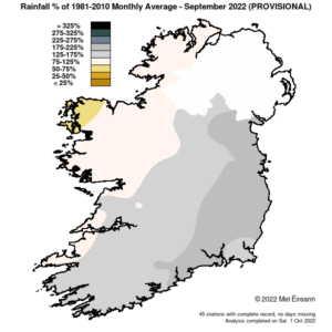
Rainfall % of 1981 – 2021 Monthly Average for September 2022 (Provisional)
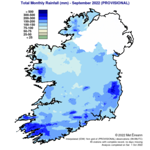
Total Monthly Rainfall (mm) for September 2022 (Provisional)
Temperature: Above average in most places
Nearly all mean air temperatures were above their LTA for the month. Deviations from mean air temperature ranged from -0.1 °C (mean temperatures 13.1 °C, 13.0 °C, 12.6 °C and 14.0 °C) at Athenry, Co Galway, Dublin Airport, Co Dublin, Mount Dillon, Co Roscommon and Shannon Airport, Co Clare re-spectively to 1.1 °C (15.0 °C mean temperature) at Roche’s Point, Co Cork. Mean temperatures ranged from 12.6 °C (0.1 °C below its LTA) at Mount Dil-lon, Co Roscommon to 15.3 °C (0.9 °C above its LTA) at Sherkin Island, Co Cork. The month’s highest temperature was reported at Newport, Co Mayo on Thursday 1st with a temperature of 22.7 °C. Both the month’s lowest air and grass minimum temperature were recorded on Saturday 17th at Mount Dillon, Co Roscommon. The lowest air minimum was -0.5 °C while the lowest grass minimum was -4.0 °C. Less than half of the stations reported ground frost. The number of days with ground frost ranged from zero days at most stations to 8 days at Mount Dillon, Co Roscommon. One station reported air frost. The number of days with air frost ranged from zero days at most stations to 1 day at Mount Dillon, Co Roscommon on Saturday 17th, which was the First Autumn Frost.
Sunshine: Sunniest in the Southwest, dull in the East
Percentage of LTA sunshine values were variable (where available) across the country. Percentage of monthly sunshine values ranged from 95% (monthly sunshine total of 118.0 hours) at Casement Aerodrome, Co Dublin to 100% (monthly sunshine total of 118.5 hours) at Shannon Airport, Co Clare. Monthly sunshine totals ranged from 101.0 hours (no LTA comparison*) at Gurteen, Co Tipperary to 133.9 hours (no LTA comparison*) at Valentia Observatory, Co Kerry. The highest number of daily sunshine hours recorded this month was 12.3 hours at Malin Head, Co Donegal on Saturday 10th. The number of dull days2 ranged from 3 days at Cork Airport, Co Cork to 8 days at Belmullet, Co Mayo.
Wind: Strong gales reported
Monthly mean wind speeds ranged from 4.6 knots (8.5 km/h) at Ballyhaise, Co Cavan to 13.6 knots (25.2 km/h) at Malin Head, Co Donegal. Gales were reported on the 26th and 30th with up to strong gale winds reported on Sunday 4th. The number of days with gales ranged from zero days at most stations to 3 days at Malin Head, Co Donegal. The number of days with up to strong gales ranged from zero days at most stations to 1 day at Malin Head, Co Done-gal. The month’s highest gust was reported at Valentia Observatory, Co Kerry on Monday 5th with 54 knots (100 km/h). The month’s highest 10-minute mean wind speed was 41 knots (76 km/h) at Malin Head, Co Donegal on Sunday 4th.
The full report is available here
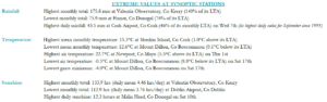
Extreme values at synoptic stations