Above average temperatures and sunshine, below average rainfall
January and the first half of February saw the North Atlantic Jetstream displaced to the south, leading to cooler than average temperatures for Ireland. The Jetstream moved north again for the second half of February bringing milder conditions. Low-pressure dominated with above average rainfall in most places, especially in the South during Febru-ary. Storm Christoph affected Ireland between 18th and 20th January. High pressure to the south and east of Ireland throughout most of March led to a mild month with below average rainfall, especially in the South and East. The high pressure shifted to the west of Ireland through April, leading to a very dry month, with cooler and sunnier conditions, as polar maritime air masses from the north dominated. The cool theme continued for May with the Jetstream displaced to the south. However, persistent and slow moving troughs of low-pressure over Ireland brought above average rainfall. June was another very dry month. High pressure kept the South and East sunny and warm, with the North and West cloudier and cooler. July saw intense thundery rainfall at times, along with a prolonged hot and dry spell, with heatwave conditions for many. This led to above average temperatures everywhere and above average rainfall in the Midlands and East. August was mild and changeable with a dry finish leading to above average temperatures once again and mostly below average rainfall. Ireland stayed on the warmer, southern side of the Jetstream through most of September, October and November. High pressure to the south of Ireland dominated through much of September and November giving warmer and drier than average conditions, while low-pressure to the west of Ireland dominated through much of October, giving warmer and wetter than average conditions. Storm Arwen brought northerly gales on 26th November. December was mild with above average rainfall for most. Storm Barra brought the strongest winds of the year on Tuesday 7th.
Rainfall: Below average at most stations
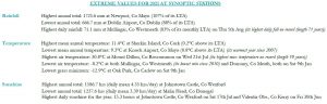
The majority of annual rainfall totals across the country were below their Long-Term Average (LTA). Percentage of annual rainfall values ranged from 84% (annual rainfall total of 793.4 mm) at Gurteen, Co Tipperary to 109% (annual rainfall total of 1062.0 mm) at Roche’s Point, Co Cork. Annual rainfall totals ranged from 666.7 mm (88% of its LTA) at Dublin Airport, Co Dublin to 1725.6 mm (107% of its LTA) at Newport, Co Mayo. The highest daily rainfall total was 71.1 mm at Mullingar, Co Westmeath on Thursday 5th Aug (its highest daily fall on record (length 71 years)). The number of rain days ranged from 170 days at Casement Aerodrome, Co Dublin to 263 days at Belmullet, Co Mayo. The number of wet days1 ranged from 110 days at Dublin Airport, Co Dublin to 216 days at Newport, Co Mayo. The number of very wet days3 ranged from 17 days at Dublin Air-port, Co Dublin to 56 days at Newport, Co Mayo. It was the driest year since 2010 at Gurteen, Co Tipperary and Malin Head , Co Donegal. It was the driest year since 2011 at Phoenix Park, Co Dublin. There were 45 separate dry periods (absolute droughts4, partial droughts5 and dry spells6) observed in Ireland during 2021.
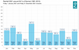
Provisional monthly gridded 2021 rainfall (%) for Ireland on a monthly basis.
Temperature: Above average everywhere
All mean annual air temperatures across the country were above their LTA. Deviations from mean air temperature for the year ranged from 0.1 °C above(9.8 °C mean tempera-ture) at Dublin Airport, Co Dublin to 0.8 °C above (9.3 °C, 10.5 °C mean temperature) at Knock Airport, Co Mayo and Phoenix Park, Co Dublin respectively. Mean tempera-tures for the year ranged from 9.3 °C (0.8 °C above its LTA) at Knock Airport, Co Mayo to 11.3 °C (0.2 °C above its LTA) at Sherkin Island, Co Cork. The year’s highest tem-perature was reported at Mount Dillon, Co Roscommon on Wednesday 21st July with a temperature of 30.8 °C (its highest max temperature on record (length 10 years)). The year’s lowest air minimum was recorded on Saturday 9th Jan at both Mullingar, Co Westmeath (its lowest min since 2010) and Dunsany, Co Meath with -8.2 °C while the lowest grass minimum was -12.9 °C reported at Oak Park, Co Carlow also on Saturday 9th Jan. All stations reported air and ground frost during the year. The number of days with ground frost ranged from 30 days at Sherkin Island, Co Cork to 128 days at Mount Dillon, Co Roscommon. The number of days with air frost ranged from 5 days at Sherkin Island, Co Cork to 55 days at Mount Dillon, Co Roscommon. It was the warmest year on record at four stations (record lengths ranging from between 10 and 16 years). These were Markree, Co Sligo, Gurteen, Co Tipperary, Athenry, Co Galway and Mount Dillon, Co Roscommon. It was the warmest year since 1997 at Ballyhaise, Co Cavan and Mullingar, Co Westmeath. It was the warmest year since 2006 at Dunsany, Co Meath and it was the warmest year since 2007 at Newport, Co Mayo, Claremorris, Co Mayo and Knock Airport, Co Mayo. Heatwaves7 were reported at 14 stations between Friday 16th July and Sunday 25th July, with six stations reporting heatwaves lasting 10 consecutive days. Overall the 2021’s average shaded air temperature in Ireland is provisionally 10.51°C which is 0.96°C above the 1961-1990 LTA.
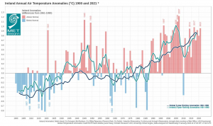
The average shaded air temperature for 2021 is provisionally 10.51°C, which is 0.96°C above the 1961-1990 Long-Term Average (LTA). 2021 is provisionally the 8th warmest year since 1900, and the 11th consecutive year above normal. Since the year 2000, only one year has been below normal, 2010 with 9.96°C (0.47°C below its LTA). The year 2007 remains Ireland’s warmest year on record at 10.77°C (1.22°C above LTA).
Sunshine: Sunniest in the South and East
All available sunshine totals were above their LTA. Percentage of annual sunshine values ranged from 108% (annual sunshine total of 1485.0 hours) at Casement Aerodrome, Co Dublin to 109% (annual sunshine total of 1415.0 hours) at Shannon Airport, Co Clare. Annual sunshine totals were highest at Johnstown Castle, Co Wexford with 1586.7 hours (No LTA comparison*). Annual sunshine totals were lowest at Malin Head, Co Donegal with 1237.6 hours (No LTA comparison*). The highest number of daily sunshine hours recorded this year was 15.3 hours at both Johnstown Castle, Co Wexford on Saturday 17th July and Valentia Observatory, Co Kerry on Friday 30th June. The number of dull days ranged from 2 days at Knock Airport, Co Mayo to 114 days at both Valentia Observatory, Co Kerry and Belmullet, Co Mayo.
Wind: Three named storms directly affected Ireland, three months with storm force winds recorded
Annual mean wind speeds ranged from 5.6 knots (10.4 km/h) at Ballyhaise, Co Cavan to 13.8 knots (25.6 km/h) at Malin Head, Co Donegal. There were numerous days with gales and strong gales with up to storm force winds on the 14th Feb, 26th Nov, 7th Dec and 8th Dec. There was violent storm force 11 winds observed on 7th Dec during storm Barra. The number of days with up to strong gales ranged from zero days at a few stations to 11 days at Malin Head, Co Donegal. The number of days with storms force winds was 2 days at both Mace Head, Co Galway and Malin Head, Co Donegal. Both the year’s highest gust and 10-minute mean wind speed were reported on the 7th Dec during storm Barra. The highest gust was 73 knots (135 km/h) reported at Sherkin Island, Co Cork while the year’s highest 10-minute mean wind speed was 56 knots (103 km/h) at Mace Head, Co Galway. Four stations had their lowest yearly mean wind on record (record length ranging from between 9 and 16 years). Thirteen stations had their lowest yearly mean wind since 2010 and Dunlin Airport, Co Dublin had its lowest yearly mean wind since 1959.
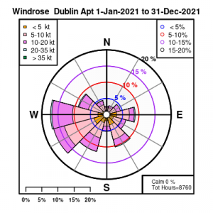
Wind rose for Dublin Airport 2021
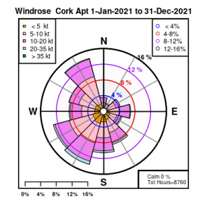
Wind rose for Cork Airport 2021
The full report is available here
EXTREME VALUES FOR 2021 AT SYNOPTIC STATIONS